You are here: Home > Network List > IU - Global Seismograph Network (GSN - IRIS/USGS) Stations List
> Station ANMO Albuquerque, New Mexico, USA > Earthquake Result Viewer
ANMO Albuquerque, New Mexico, USA - Earthquake Result Viewer
| Earthquake location: |
Peru-Brazil Border Region |
| Earthquake latitude/longitude: |
-7.6/-74.5 |
| Earthquake time(UTC): |
2011/08/24 (236) 17:46:11 GMT |
| Earthquake Depth: |
147 km |
| Earthquake Magnitude: |
6.8 MB, 7.0 MW, 7.0 MW |
| Earthquake Catalog/Contributor: |
WHDF/NEIC |
|
| Network: |
IU Global Seismograph Network (GSN - IRIS/USGS) |
| Station: |
ANMO Albuquerque, New Mexico, USA |
| Lat/Lon: |
34.95 N/106.46 W |
| Elevation: |
1820 m |
|
| Distance: |
52.0 deg |
| Az: |
326.534 deg |
| Baz: |
138.288 deg |
| Ray Param: |
0.06655406 |
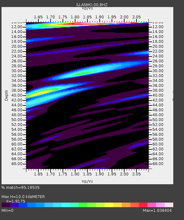
| Estimated Moho Depth: |
10.0 km |
| Estimated Crust Vp/Vs: |
1.92 |
| Assumed Crust Vp: |
6.502 km/s |
| Estimated Crust Vs: |
3.391 km/s |
| Estimated Crust Poisson's Ratio: |
0.31 |
|
| Radial Match: |
95.19535 % |
| Radial Bump: |
400 |
| Transverse Match: |
88.01231 % |
| Transverse Bump: |
400 |
| SOD ConfigId: |
558545 |
| Insert Time: |
2013-09-19 01:45:50.032 +0000 |
| GWidth: |
2.5 |
| Max Bumps: |
400 |
| Tol: |
0.001 |
|

Signal To Noise
| Channel | StoN | STA | LTA |
| IU:ANMO:00:BHZ:20110824T17:54:35.268988Z | 104.74105 | 1.4165765E-5 | 1.3524559E-7 |
| IU:ANMO:00:BH1:20110824T17:54:35.268988Z | 83.024765 | 7.5139874E-6 | 9.0502965E-8 |
| IU:ANMO:00:BH2:20110824T17:54:35.268988Z | 16.138725 | 1.4657232E-6 | 9.0820265E-8 |
| Arrivals |
| Ps | 1.5 SECOND |
| PpPs | 4.3 SECOND |
| PsPs/PpSs | 5.7 SECOND |


