You are here: Home > Network List > IU - Global Seismograph Network (GSN - IRIS/USGS) Stations List
> Station RAR Rarotonga, Cook Islands > Earthquake Result Viewer
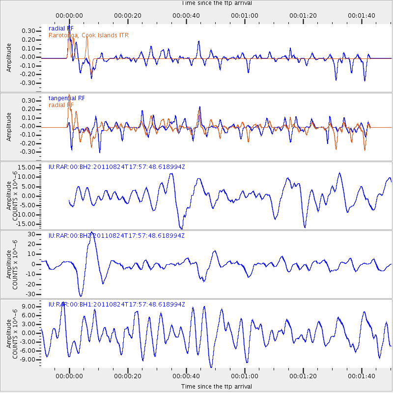
RAR Rarotonga, Cook Islands - Earthquake Result Viewer
*The percent match for this event was below the threshold and hence no stack was calculated.
| Earthquake location: |
Peru-Brazil Border Region |
| Earthquake latitude/longitude: |
-7.6/-74.5 |
| Earthquake time(UTC): |
2011/08/24 (236) 17:46:11 GMT |
| Earthquake Depth: |
147 km |
| Earthquake Magnitude: |
6.8 MB, 7.0 MW, 7.0 MW |
| Earthquake Catalog/Contributor: |
WHDF/NEIC |
|
| Network: |
IU Global Seismograph Network (GSN - IRIS/USGS) |
| Station: |
RAR Rarotonga, Cook Islands |
| Lat/Lon: |
21.21 S/159.77 W |
| Elevation: |
28 m |
|
| Distance: |
82.9 deg |
| Az: |
249.57 deg |
| Baz: |
95.419 deg |
| Ray Param: |
$rayparam |
*The percent match for this event was below the threshold and hence was not used in the summary stack. |
|
| Radial Match: |
70.84723 % |
| Radial Bump: |
400 |
| Transverse Match: |
62.49841 % |
| Transverse Bump: |
400 |
| SOD ConfigId: |
558545 |
| Insert Time: |
2013-09-19 01:46:21.511 +0000 |
| GWidth: |
2.5 |
| Max Bumps: |
400 |
| Tol: |
0.001 |
|
Signal To Noise
| Channel | StoN | STA | LTA |
| IU:RAR:00:BHZ:20110824T17:57:48.618994Z | 6.130279 | 1.5905413E-5 | 2.5945658E-6 |
| IU:RAR:00:BH1:20110824T17:57:48.618994Z | 1.3874165 | 4.754258E-6 | 3.4266986E-6 |
| IU:RAR:00:BH2:20110824T17:57:48.618994Z | 2.4518354 | 6.6642374E-6 | 2.7180606E-6 |
| Arrivals |
| Ps | |
| PpPs | |
| PsPs/PpSs | |


