You are here: Home > Network List > US - United States National Seismic Network Stations List
> Station AMTX Amarillo, Texas, USA > Earthquake Result Viewer
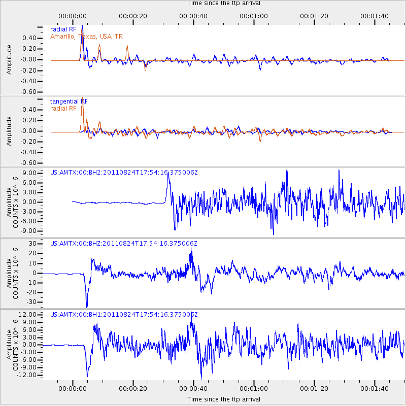
AMTX Amarillo, Texas, USA - Earthquake Result Viewer
*The percent match for this event was below the threshold and hence no stack was calculated.
| Earthquake location: |
Peru-Brazil Border Region |
| Earthquake latitude/longitude: |
-7.6/-74.5 |
| Earthquake time(UTC): |
2011/08/24 (236) 17:46:11 GMT |
| Earthquake Depth: |
147 km |
| Earthquake Magnitude: |
6.8 MB, 7.0 MW, 7.0 MW |
| Earthquake Catalog/Contributor: |
WHDF/NEIC |
|
| Network: |
US United States National Seismic Network |
| Station: |
AMTX Amarillo, Texas, USA |
| Lat/Lon: |
34.53 N/101.41 W |
| Elevation: |
1010 m |
|
| Distance: |
49.1 deg |
| Az: |
330.378 deg |
| Baz: |
143.599 deg |
| Ray Param: |
$rayparam |
*The percent match for this event was below the threshold and hence was not used in the summary stack. |
|
| Radial Match: |
91.556335 % |
| Radial Bump: |
400 |
| Transverse Match: |
78.88107 % |
| Transverse Bump: |
400 |
| SOD ConfigId: |
558545 |
| Insert Time: |
2013-09-19 01:46:54.523 +0000 |
| GWidth: |
2.5 |
| Max Bumps: |
400 |
| Tol: |
0.001 |
|
Signal To Noise
| Channel | StoN | STA | LTA |
| US:AMTX:00:BHZ:20110824T17:54:16.375006Z | 132.1757 | 9.811562E-6 | 7.423122E-8 |
| US:AMTX:00:BH1:20110824T17:54:16.375006Z | 20.895576 | 2.842911E-6 | 1.3605325E-7 |
| US:AMTX:00:BH2:20110824T17:54:16.375006Z | 16.16143 | 2.1913797E-6 | 1.3559318E-7 |
| Arrivals |
| Ps | |
| PpPs | |
| PsPs/PpSs | |


