You are here: Home > Network List > US - United States National Seismic Network Stations List
> Station DGMT Dagmar, Montana, USA > Earthquake Result Viewer
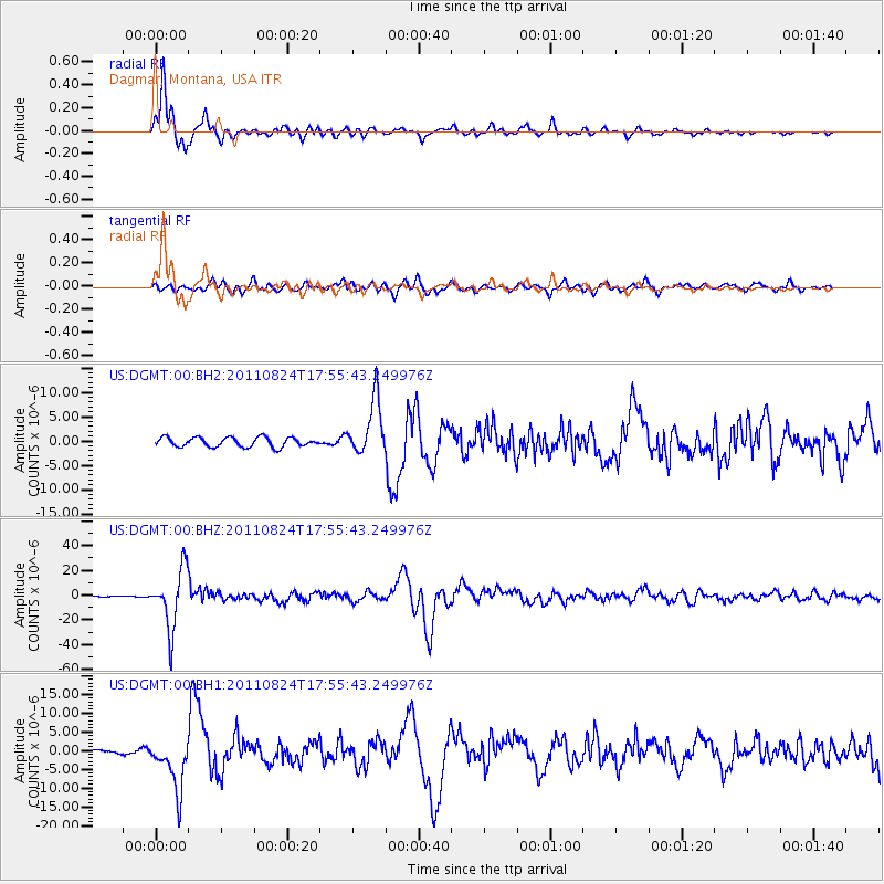
DGMT Dagmar, Montana, USA - Earthquake Result Viewer
*The percent match for this event was below the threshold and hence no stack was calculated.
| Earthquake location: |
Peru-Brazil Border Region |
| Earthquake latitude/longitude: |
-7.6/-74.5 |
| Earthquake time(UTC): |
2011/08/24 (236) 17:46:11 GMT |
| Earthquake Depth: |
147 km |
| Earthquake Magnitude: |
6.8 MB, 7.0 MW, 7.0 MW |
| Earthquake Catalog/Contributor: |
WHDF/NEIC |
|
| Network: |
US United States National Seismic Network |
| Station: |
DGMT Dagmar, Montana, USA |
| Lat/Lon: |
48.47 N/104.20 W |
| Elevation: |
0.0 m |
|
| Distance: |
61.7 deg |
| Az: |
338.021 deg |
| Baz: |
146.121 deg |
| Ray Param: |
$rayparam |
*The percent match for this event was below the threshold and hence was not used in the summary stack. |
|
| Radial Match: |
96.66792 % |
| Radial Bump: |
360 |
| Transverse Match: |
76.69722 % |
| Transverse Bump: |
400 |
| SOD ConfigId: |
558545 |
| Insert Time: |
2013-09-19 01:47:19.846 +0000 |
| GWidth: |
2.5 |
| Max Bumps: |
400 |
| Tol: |
0.001 |
|
Signal To Noise
| Channel | StoN | STA | LTA |
| US:DGMT:00:BHZ:20110824T17:55:43.249976Z | 66.71673 | 2.3984543E-5 | 3.594982E-7 |
| US:DGMT:00:BH1:20110824T17:55:43.249976Z | 7.80359 | 6.9221505E-6 | 8.8704695E-7 |
| US:DGMT:00:BH2:20110824T17:55:43.249976Z | 5.893955 | 5.6982312E-6 | 9.667924E-7 |
| Arrivals |
| Ps | |
| PpPs | |
| PsPs/PpSs | |


