You are here: Home > Network List > US - United States National Seismic Network Stations List
> Station NATX Nacogdoches, Texas, USA > Earthquake Result Viewer
NATX Nacogdoches, Texas, USA - Earthquake Result Viewer

| Earthquake location: |
Peru-Brazil Border Region |
| Earthquake latitude/longitude: |
-7.6/-74.5 |
| Earthquake time(UTC): |
2011/08/24 (236) 17:46:11 GMT |
| Earthquake Depth: |
147 km |
| Earthquake Magnitude: |
6.8 MB, 7.0 MW, 7.0 MW |
| Earthquake Catalog/Contributor: |
WHDF/NEIC |
|
| Network: |
US United States National Seismic Network |
| Station: |
NATX Nacogdoches, Texas, USA |
| Lat/Lon: |
31.76 N/94.66 W |
| Elevation: |
156 m |
|
| Distance: |
43.6 deg |
| Az: |
334.859 deg |
| Baz: |
150.372 deg |
| Ray Param: |
0.07187544 |
| Estimated Moho Depth: |
10.0 km |
| Estimated Crust Vp/Vs: |
1.60 |
| Assumed Crust Vp: |
5.738 km/s |
| Estimated Crust Vs: |
3.587 km/s |
| Estimated Crust Poisson's Ratio: |
0.18 |
|
| Radial Match: |
99.99946 % |
| Radial Bump: |
2 |
| Transverse Match: |
80.27934 % |
| Transverse Bump: |
400 |
| SOD ConfigId: |
558545 |
| Insert Time: |
2013-09-19 01:48:25.340 +0000 |
| GWidth: |
2.5 |
| Max Bumps: |
400 |
| Tol: |
0.001 |
|
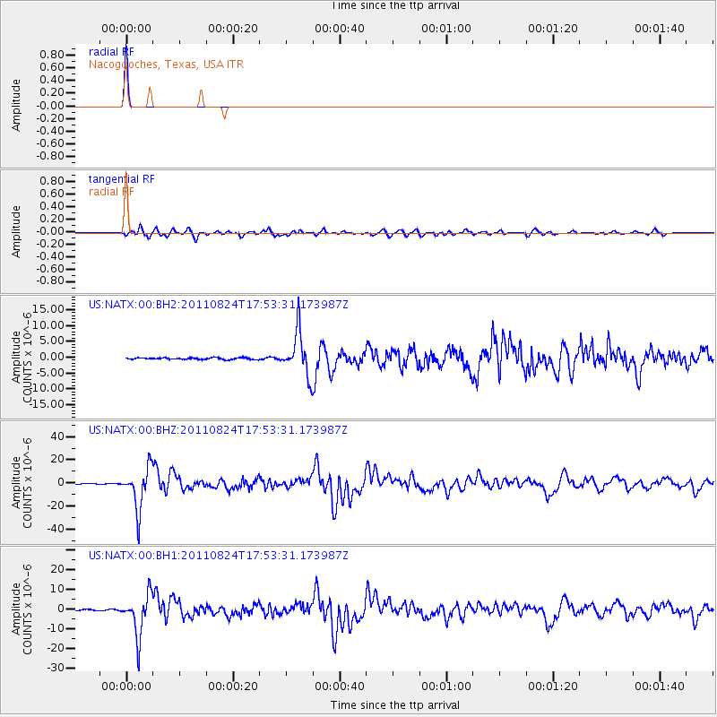
Signal To Noise
| Channel | StoN | STA | LTA |
| US:NATX:00:BHZ:20110824T17:53:31.173987Z | 69.105606 | 1.8276945E-5 | 2.6447847E-7 |
| US:NATX:00:BH1:20110824T17:53:31.173987Z | 42.13603 | 1.0710461E-5 | 2.541877E-7 |
| US:NATX:00:BH2:20110824T17:53:31.173987Z | 24.150553 | 6.874276E-6 | 2.846426E-7 |
| Arrivals |
| Ps | 1.1 SECOND |
| PpPs | 4.3 SECOND |
| PsPs/PpSs | 5.4 SECOND |


