You are here: Home > Network List > US - United States National Seismic Network Stations List
> Station TPNV Topopah Spring, Nevada, USA > Earthquake Result Viewer
TPNV Topopah Spring, Nevada, USA - Earthquake Result Viewer
| Earthquake location: |
Peru-Brazil Border Region |
| Earthquake latitude/longitude: |
-7.6/-74.5 |
| Earthquake time(UTC): |
2011/08/24 (236) 17:46:11 GMT |
| Earthquake Depth: |
147 km |
| Earthquake Magnitude: |
6.8 MB, 7.0 MW, 7.0 MW |
| Earthquake Catalog/Contributor: |
WHDF/NEIC |
|
| Network: |
US United States National Seismic Network |
| Station: |
TPNV Topopah Spring, Nevada, USA |
| Lat/Lon: |
36.95 N/116.25 W |
| Elevation: |
1600 m |
|
| Distance: |
59.1 deg |
| Az: |
321.582 deg |
| Baz: |
129.747 deg |
| Ray Param: |
0.061957043 |
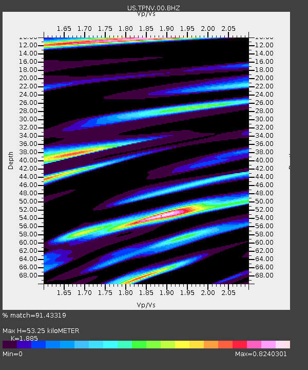
| Estimated Moho Depth: |
53.25 km |
| Estimated Crust Vp/Vs: |
1.88 |
| Assumed Crust Vp: |
6.279 km/s |
| Estimated Crust Vs: |
3.331 km/s |
| Estimated Crust Poisson's Ratio: |
0.30 |
|
| Radial Match: |
91.43319 % |
| Radial Bump: |
400 |
| Transverse Match: |
85.597145 % |
| Transverse Bump: |
400 |
| SOD ConfigId: |
558545 |
| Insert Time: |
2013-09-19 01:48:48.427 +0000 |
| GWidth: |
2.5 |
| Max Bumps: |
400 |
| Tol: |
0.001 |
|

Signal To Noise
| Channel | StoN | STA | LTA |
| US:TPNV:00:BHZ:20110824T17:55:25.824011Z | 142.489 | 1.1776572E-5 | 8.2648995E-8 |
| US:TPNV:00:BH1:20110824T17:55:25.824011Z | 45.26699 | 3.3409374E-6 | 7.3805154E-8 |
| US:TPNV:00:BH2:20110824T17:55:25.824011Z | 47.52418 | 4.5482916E-6 | 9.5704785E-8 |
| Arrivals |
| Ps | 7.8 SECOND |
| PpPs | 23 SECOND |
| PsPs/PpSs | 31 SECOND |


