You are here: Home > Network List > II - Global Seismograph Network (GSN - IRIS/IDA) Stations List
> Station ABPO Ambohimpanompo, Madagascar > Earthquake Result Viewer
ABPO Ambohimpanompo, Madagascar - Earthquake Result Viewer

| Earthquake location: |
Banda Sea |
| Earthquake latitude/longitude: |
-6.4/126.8 |
| Earthquake time(UTC): |
2011/08/30 (242) 06:57:41 GMT |
| Earthquake Depth: |
470 km |
| Earthquake Magnitude: |
6.0 MB, 6.9 MW, 6.9 MW |
| Earthquake Catalog/Contributor: |
WHDF/NEIC |
|
| Network: |
II Global Seismograph Network (GSN - IRIS/IDA) |
| Station: |
ABPO Ambohimpanompo, Madagascar |
| Lat/Lon: |
19.02 S/47.23 E |
| Elevation: |
1528 m |
|
| Distance: |
78.1 deg |
| Az: |
251.959 deg |
| Baz: |
92.671 deg |
| Ray Param: |
0.048501734 |
| Estimated Moho Depth: |
45.75 km |
| Estimated Crust Vp/Vs: |
1.64 |
| Assumed Crust Vp: |
6.642 km/s |
| Estimated Crust Vs: |
4.044 km/s |
| Estimated Crust Poisson's Ratio: |
0.21 |
|
| Radial Match: |
88.22497 % |
| Radial Bump: |
400 |
| Transverse Match: |
58.088627 % |
| Transverse Bump: |
400 |
| SOD ConfigId: |
558545 |
| Insert Time: |
2013-09-19 01:59:58.256 +0000 |
| GWidth: |
2.5 |
| Max Bumps: |
400 |
| Tol: |
0.001 |
|
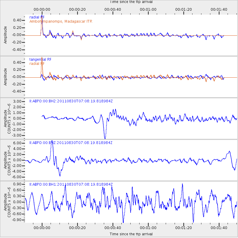
Signal To Noise
| Channel | StoN | STA | LTA |
| II:ABPO:00:BHZ:20110830T07:08:19.818984Z | 3.9321027 | 8.7913577E-7 | 2.2357905E-7 |
| II:ABPO:00:BH1:20110830T07:08:19.818984Z | 1.3952638 | 2.7061628E-7 | 1.939535E-7 |
| II:ABPO:00:BH2:20110830T07:08:19.818984Z | 3.4362009 | 6.42449E-7 | 1.869649E-7 |
| Arrivals |
| Ps | 4.6 SECOND |
| PpPs | 18 SECOND |
| PsPs/PpSs | 22 SECOND |


