You are here: Home > Network List > II - Global Seismograph Network (GSN - IRIS/IDA) Stations List
> Station PALK Pallekele, Sri Lanka > Earthquake Result Viewer
PALK Pallekele, Sri Lanka - Earthquake Result Viewer
| Earthquake location: |
Banda Sea |
| Earthquake latitude/longitude: |
-6.4/126.8 |
| Earthquake time(UTC): |
2011/08/30 (242) 06:57:41 GMT |
| Earthquake Depth: |
470 km |
| Earthquake Magnitude: |
6.0 MB, 6.9 MW, 6.9 MW |
| Earthquake Catalog/Contributor: |
WHDF/NEIC |
|
| Network: |
II Global Seismograph Network (GSN - IRIS/IDA) |
| Station: |
PALK Pallekele, Sri Lanka |
| Lat/Lon: |
7.27 N/80.70 E |
| Elevation: |
460 m |
|
| Distance: |
47.9 deg |
| Az: |
285.702 deg |
| Baz: |
105.315 deg |
| Ray Param: |
0.067617916 |
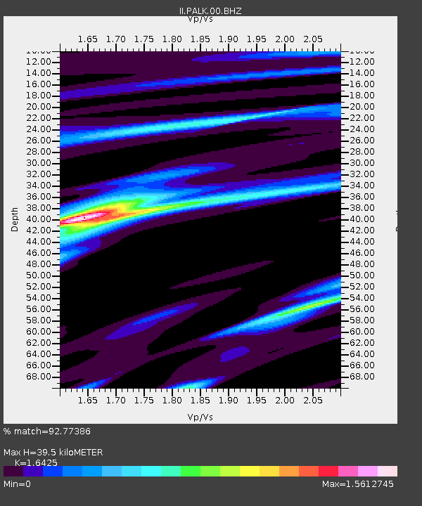
| Estimated Moho Depth: |
39.5 km |
| Estimated Crust Vp/Vs: |
1.64 |
| Assumed Crust Vp: |
6.545 km/s |
| Estimated Crust Vs: |
3.985 km/s |
| Estimated Crust Poisson's Ratio: |
0.21 |
|
| Radial Match: |
92.77386 % |
| Radial Bump: |
305 |
| Transverse Match: |
78.23873 % |
| Transverse Bump: |
400 |
| SOD ConfigId: |
558545 |
| Insert Time: |
2013-09-19 02:00:08.927 +0000 |
| GWidth: |
2.5 |
| Max Bumps: |
400 |
| Tol: |
0.001 |
|
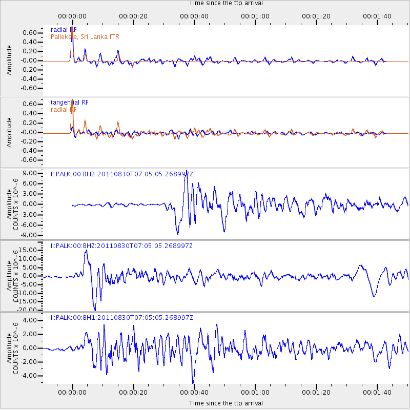
Signal To Noise
| Channel | StoN | STA | LTA |
| II:PALK:00:BHZ:20110830T07:05:05.268997Z | 22.357124 | 6.0938823E-6 | 2.7257005E-7 |
| II:PALK:00:BH1:20110830T07:05:05.268997Z | 5.108725 | 8.9606306E-7 | 1.7539855E-7 |
| II:PALK:00:BH2:20110830T07:05:05.268997Z | 12.472004 | 3.246655E-6 | 2.6031543E-7 |
| Arrivals |
| Ps | 4.1 SECOND |
| PpPs | 15 SECOND |
| PsPs/PpSs | 19 SECOND |


