You are here: Home > Network List > IU - Global Seismograph Network (GSN - IRIS/USGS) Stations List
> Station HNR Honiara, Solomon Islands > Earthquake Result Viewer
HNR Honiara, Solomon Islands - Earthquake Result Viewer

| Earthquake location: |
Banda Sea |
| Earthquake latitude/longitude: |
-6.4/126.8 |
| Earthquake time(UTC): |
2011/08/30 (242) 06:57:41 GMT |
| Earthquake Depth: |
470 km |
| Earthquake Magnitude: |
6.0 MB, 6.9 MW, 6.9 MW |
| Earthquake Catalog/Contributor: |
WHDF/NEIC |
|
| Network: |
IU Global Seismograph Network (GSN - IRIS/USGS) |
| Station: |
HNR Honiara, Solomon Islands |
| Lat/Lon: |
9.44 S/159.95 E |
| Elevation: |
100 m |
|
| Distance: |
33.0 deg |
| Az: |
97.493 deg |
| Baz: |
272.83 deg |
| Ray Param: |
0.076376654 |
| Estimated Moho Depth: |
42.25 km |
| Estimated Crust Vp/Vs: |
1.76 |
| Assumed Crust Vp: |
6.183 km/s |
| Estimated Crust Vs: |
3.518 km/s |
| Estimated Crust Poisson's Ratio: |
0.26 |
|
| Radial Match: |
84.4428 % |
| Radial Bump: |
400 |
| Transverse Match: |
83.58011 % |
| Transverse Bump: |
400 |
| SOD ConfigId: |
558545 |
| Insert Time: |
2013-09-19 02:00:28.847 +0000 |
| GWidth: |
2.5 |
| Max Bumps: |
400 |
| Tol: |
0.001 |
|
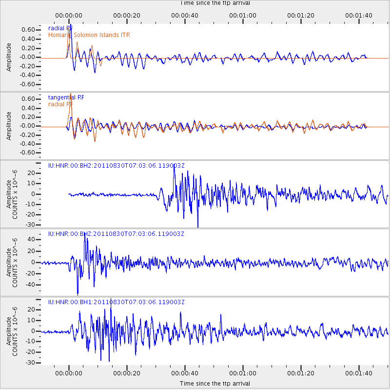
Signal To Noise
| Channel | StoN | STA | LTA |
| IU:HNR:00:BHZ:20110830T07:03:06.119003Z | 19.60463 | 1.6622249E-5 | 8.4787365E-7 |
| IU:HNR:00:BH1:20110830T07:03:06.119003Z | 9.86779 | 6.271942E-6 | 6.355974E-7 |
| IU:HNR:00:BH2:20110830T07:03:06.119003Z | 10.522557 | 6.6822695E-6 | 6.3504234E-7 |
| Arrivals |
| Ps | 5.5 SECOND |
| PpPs | 18 SECOND |
| PsPs/PpSs | 23 SECOND |


