You are here: Home > Network List > CN - Canadian National Seismograph Network Stations List
> Station INK INUVIK, NT, CANADA.ANADA > Earthquake Result Viewer
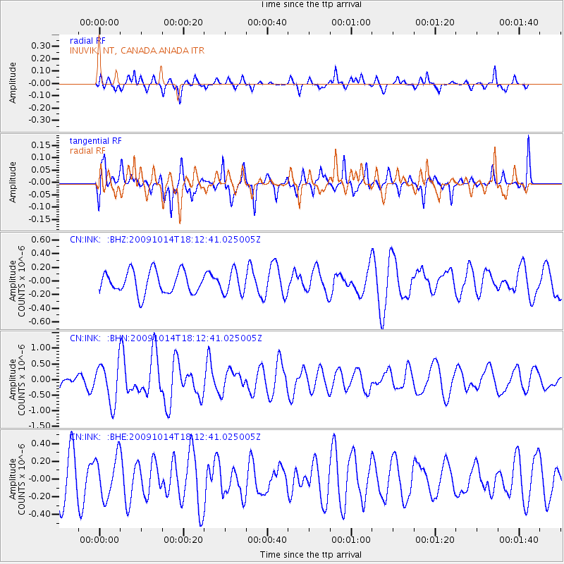
INK INUVIK, NT, CANADA.ANADA - Earthquake Result Viewer
*The percent match for this event was below the threshold and hence no stack was calculated.
| Earthquake location: |
Samoa Islands Region |
| Earthquake latitude/longitude: |
-14.9/-174.8 |
| Earthquake time(UTC): |
2009/10/14 (287) 18:00:21 GMT |
| Earthquake Depth: |
10 km |
| Earthquake Magnitude: |
5.7 MB, 6.0 MS, 6.3 MW, 6.2 MW |
| Earthquake Catalog/Contributor: |
WHDF/NEIC |
|
| Network: |
CN Canadian National Seismograph Network |
| Station: |
INK INUVIK, NT, CANADA.ANADA |
| Lat/Lon: |
68.31 N/133.52 W |
| Elevation: |
40 m |
|
| Distance: |
88.1 deg |
| Az: |
14.213 deg |
| Baz: |
219.676 deg |
| Ray Param: |
$rayparam |
*The percent match for this event was below the threshold and hence was not used in the summary stack. |
|
| Radial Match: |
54.356106 % |
| Radial Bump: |
361 |
| Transverse Match: |
58.948177 % |
| Transverse Bump: |
373 |
| SOD ConfigId: |
2622 |
| Insert Time: |
2010-02-27 06:21:23.435 +0000 |
| GWidth: |
2.5 |
| Max Bumps: |
400 |
| Tol: |
0.001 |
|
Signal To Noise
| Channel | StoN | STA | LTA |
| CN:INK: :BHN:20091014T18:12:41.025005Z | 2.5156615 | 6.553575E-7 | 2.6051103E-7 |
| CN:INK: :BHE:20091014T18:12:41.025005Z | 1.1277987 | 2.3493038E-7 | 2.0830879E-7 |
| CN:INK: :BHZ:20091014T18:12:41.025005Z | 1.0403423 | 1.6776046E-7 | 1.6125504E-7 |
| Arrivals |
| Ps | |
| PpPs | |
| PsPs/PpSs | |


