You are here: Home > Network List > CN - Canadian National Seismograph Network Stations List
> Station INK INUVIK, NT, CANADA.ANADA > Earthquake Result Viewer
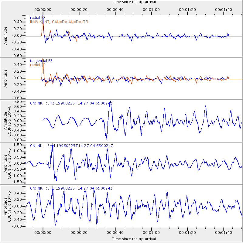
INK INUVIK, NT, CANADA.ANADA - Earthquake Result Viewer
*The percent match for this event was below the threshold and hence no stack was calculated.
| Earthquake location: |
Near Coast Of Guatemala |
| Earthquake latitude/longitude: |
13.0/-91.1 |
| Earthquake time(UTC): |
1996/02/25 (056) 14:17:21 GMT |
| Earthquake Depth: |
33 km |
| Earthquake Magnitude: |
5.5 MB, 5.2 MS, 5.9 UNKNOWN, 5.8 MW |
| Earthquake Catalog/Contributor: |
WHDF/NEIC |
|
| Network: |
CN Canadian National Seismograph Network |
| Station: |
INK INUVIK, NT, CANADA.ANADA |
| Lat/Lon: |
68.31 N/133.52 W |
| Elevation: |
40 m |
|
| Distance: |
61.6 deg |
| Az: |
343.424 deg |
| Baz: |
131.594 deg |
| Ray Param: |
$rayparam |
*The percent match for this event was below the threshold and hence was not used in the summary stack. |
|
| Radial Match: |
73.23687 % |
| Radial Bump: |
311 |
| Transverse Match: |
66.58053 % |
| Transverse Bump: |
400 |
| SOD ConfigId: |
4480 |
| Insert Time: |
2010-02-27 06:21:44.645 +0000 |
| GWidth: |
2.5 |
| Max Bumps: |
400 |
| Tol: |
0.001 |
|
Signal To Noise
| Channel | StoN | STA | LTA |
| CN:INK: :BHN:19960225T14:27:04.650024Z | 1.9465123 | 3.239566E-7 | 1.6642925E-7 |
| CN:INK: :BHE:19960225T14:27:04.650024Z | 1.4165502 | 1.9777534E-7 | 1.396176E-7 |
| CN:INK: :BHZ:19960225T14:27:04.650024Z | 1.3527083 | 1.8104348E-7 | 1.3383777E-7 |
| Arrivals |
| Ps | |
| PpPs | |
| PsPs/PpSs | |


