You are here: Home > Network List > CN - Canadian National Seismograph Network Stations List
> Station INK INUVIK, NT, CANADA.ANADA > Earthquake Result Viewer
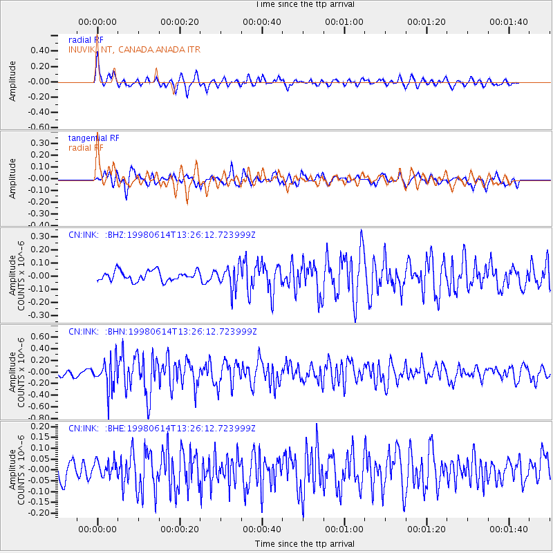
INK INUVIK, NT, CANADA.ANADA - Earthquake Result Viewer
*The percent match for this event was below the threshold and hence no stack was calculated.
| Earthquake location: |
Near East Coast Of Honshu, Japan |
| Earthquake latitude/longitude: |
35.4/140.5 |
| Earthquake time(UTC): |
1998/06/14 (165) 13:17:08 GMT |
| Earthquake Depth: |
45 km |
| Earthquake Magnitude: |
5.5 MB, 5.3 MS, 5.8 UNKNOWN, 5.8 MW |
| Earthquake Catalog/Contributor: |
WHDF/NEIC |
|
| Network: |
CN Canadian National Seismograph Network |
| Station: |
INK INUVIK, NT, CANADA.ANADA |
| Lat/Lon: |
68.31 N/133.52 W |
| Elevation: |
40 m |
|
| Distance: |
56.2 deg |
| Az: |
26.508 deg |
| Baz: |
281.159 deg |
| Ray Param: |
$rayparam |
*The percent match for this event was below the threshold and hence was not used in the summary stack. |
|
| Radial Match: |
77.67448 % |
| Radial Bump: |
400 |
| Transverse Match: |
66.023766 % |
| Transverse Bump: |
400 |
| SOD ConfigId: |
4480 |
| Insert Time: |
2010-02-27 06:21:45.897 +0000 |
| GWidth: |
2.5 |
| Max Bumps: |
400 |
| Tol: |
0.001 |
|
Signal To Noise
| Channel | StoN | STA | LTA |
| CN:INK: :BHN:19980614T13:26:12.723999Z | 3.666559 | 2.548046E-7 | 6.9494206E-8 |
| CN:INK: :BHE:19980614T13:26:12.723999Z | 0.7313901 | 3.8153903E-8 | 5.2166286E-8 |
| CN:INK: :BHZ:19980614T13:26:12.723999Z | 2.3352165 | 8.820108E-8 | 3.776998E-8 |
| Arrivals |
| Ps | |
| PpPs | |
| PsPs/PpSs | |


