You are here: Home > Network List > US - United States National Seismic Network Stations List
> Station BOZ Bozeman, Montana, USA > Earthquake Result Viewer
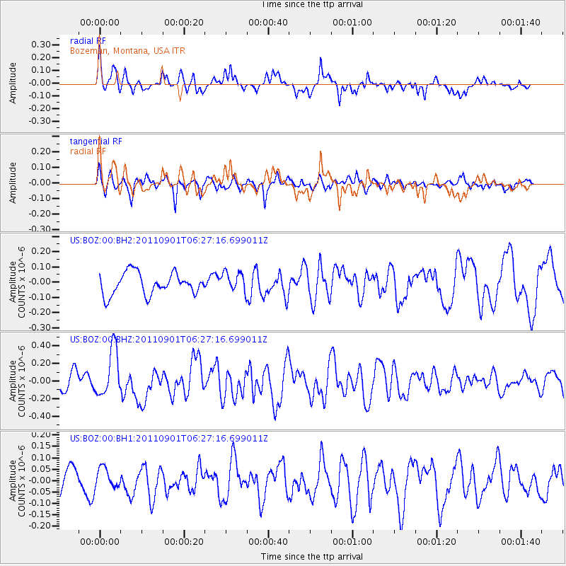
BOZ Bozeman, Montana, USA - Earthquake Result Viewer
*The percent match for this event was below the threshold and hence no stack was calculated.
| Earthquake location: |
Santa Cruz Islands |
| Earthquake latitude/longitude: |
-12.4/166.7 |
| Earthquake time(UTC): |
2011/09/01 (244) 06:14:38 GMT |
| Earthquake Depth: |
39 km |
| Earthquake Magnitude: |
5.7 MB, 5.6 MS, 6.1 MW, 6.0 MW |
| Earthquake Catalog/Contributor: |
WHDF/NEIC |
|
| Network: |
US United States National Seismic Network |
| Station: |
BOZ Bozeman, Montana, USA |
| Lat/Lon: |
45.65 N/111.63 W |
| Elevation: |
1589 m |
|
| Distance: |
93.0 deg |
| Az: |
44.037 deg |
| Baz: |
255.53 deg |
| Ray Param: |
$rayparam |
*The percent match for this event was below the threshold and hence was not used in the summary stack. |
|
| Radial Match: |
77.01695 % |
| Radial Bump: |
400 |
| Transverse Match: |
57.453537 % |
| Transverse Bump: |
400 |
| SOD ConfigId: |
558545 |
| Insert Time: |
2013-09-19 02:08:32.939 +0000 |
| GWidth: |
2.5 |
| Max Bumps: |
400 |
| Tol: |
0.001 |
|
Signal To Noise
| Channel | StoN | STA | LTA |
| US:BOZ:00:BHZ:20110901T06:27:16.699011Z | 3.039565 | 2.7736493E-7 | 9.1251515E-8 |
| US:BOZ:00:BH1:20110901T06:27:16.699011Z | 0.80221057 | 4.1093905E-8 | 5.1225832E-8 |
| US:BOZ:00:BH2:20110901T06:27:16.699011Z | 0.94345605 | 6.670385E-8 | 7.070159E-8 |
| Arrivals |
| Ps | |
| PpPs | |
| PsPs/PpSs | |


