You are here: Home > Network List > US - United States National Seismic Network Stations List
> Station MSO Missoula, Montana, USA > Earthquake Result Viewer
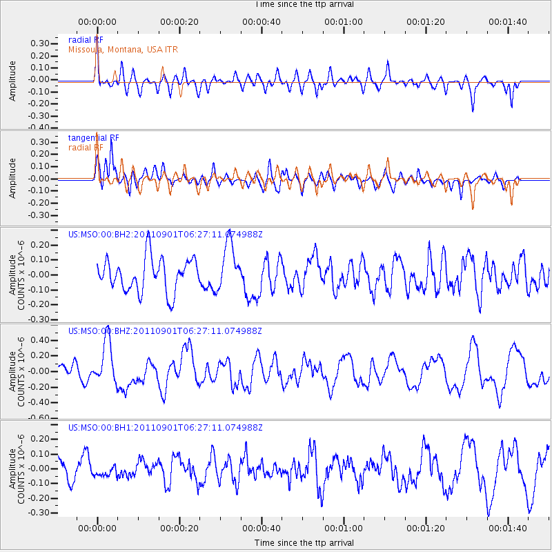
MSO Missoula, Montana, USA - Earthquake Result Viewer
*The percent match for this event was below the threshold and hence no stack was calculated.
| Earthquake location: |
Santa Cruz Islands |
| Earthquake latitude/longitude: |
-12.4/166.7 |
| Earthquake time(UTC): |
2011/09/01 (244) 06:14:38 GMT |
| Earthquake Depth: |
39 km |
| Earthquake Magnitude: |
5.7 MB, 5.6 MS, 6.1 MW, 6.0 MW |
| Earthquake Catalog/Contributor: |
WHDF/NEIC |
|
| Network: |
US United States National Seismic Network |
| Station: |
MSO Missoula, Montana, USA |
| Lat/Lon: |
46.83 N/113.94 W |
| Elevation: |
1264 m |
|
| Distance: |
91.8 deg |
| Az: |
42.472 deg |
| Baz: |
253.932 deg |
| Ray Param: |
$rayparam |
*The percent match for this event was below the threshold and hence was not used in the summary stack. |
|
| Radial Match: |
65.86572 % |
| Radial Bump: |
400 |
| Transverse Match: |
65.1975 % |
| Transverse Bump: |
400 |
| SOD ConfigId: |
558545 |
| Insert Time: |
2013-09-19 02:09:00.320 +0000 |
| GWidth: |
2.5 |
| Max Bumps: |
400 |
| Tol: |
0.001 |
|
Signal To Noise
| Channel | StoN | STA | LTA |
| US:MSO:00:BHZ:20110901T06:27:11.074988Z | 3.6125693 | 2.8892993E-7 | 7.997907E-8 |
| US:MSO:00:BH1:20110901T06:27:11.074988Z | 0.4653631 | 3.392509E-8 | 7.2900264E-8 |
| US:MSO:00:BH2:20110901T06:27:11.074988Z | 1.4550297 | 1.6173144E-7 | 1.1115336E-7 |
| Arrivals |
| Ps | |
| PpPs | |
| PsPs/PpSs | |


