ANMO Albuquerque, New Mexico, USA - Earthquake Result Viewer
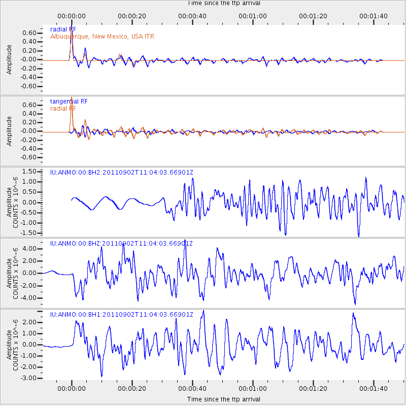
Earthquake location: Fox Islands, Aleutian Islands
Earthquake latitude/longitude: 52.2/-171.7
Earthquake time(UTC): 2011/09/02 (245) 10:55:53 GMT
Earthquake Depth: 32 km
Earthquake Magnitude: 6.5 MB, 6.9 MS, 6.8 MW, 6.8 MW
Earthquake Catalog/Contributor: WHDF/NEIC
Network: IU Global Seismograph Network (GSN - IRIS/USGS)
Station: ANMO Albuquerque, New Mexico, USA
Lat/Lon: 34.95 N/106.46 W
Elevation: 1820 m
Distance: 48.6 deg
Az: 83.862 deg
Baz: 311.806 deg
Ray Param: 0.06917749
Estimated Moho Depth: 43.0 km
Estimated Crust Vp/Vs: 1.64
Assumed Crust Vp: 6.502 km/s
Estimated Crust Vs: 3.97 km/s
Estimated Crust Poisson's Ratio: 0.20
Radial Match: 94.49281 %
Radial Bump: 316
Transverse Match: 71.06527 %
Transverse Bump: 400
SOD ConfigId: 558545
Insert Time: 2013-09-19 02:10:48.674 +0000
GWidth: 2.5
Max Bumps: 400
Tol: 0.001

Signal To Noise

ChannelStoNSTALTA
IU:ANMO:00:BHZ:20110902T11:04:03.66901Z8.5559112.2191064E-62.593653E-7
IU:ANMO:00:BH1:20110902T11:04:03.66901Z15.4997051.31257E-68.468354E-8
IU:ANMO:00:BH2:20110902T11:04:03.66901Z2.19274544.0786367E-71.8600593E-7
Arrivals
Ps4.5 SECOND
PpPs16 SECOND
PsPs/PpSs21 SECOND