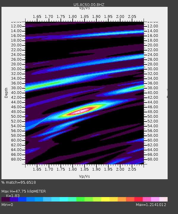
ACSO Alum Creek State Park, Ohio, USA - Earthquake Result Viewer

Earthquake location: Fox Islands, Aleutian Islands
Earthquake latitude/longitude: 52.2/-171.7
Earthquake time(UTC): 2011/09/02 (245) 10:55:53 GMT
Earthquake Depth: 32 km
Earthquake Magnitude: 6.5 MB, 6.9 MS, 6.8 MW, 6.8 MW
Earthquake Catalog/Contributor: WHDF/NEIC
Network: US United States National Seismic Network
Station: ACSO Alum Creek State Park, Ohio, USA
Lat/Lon: 40.23 N/82.98 W
Elevation: 288 m
Distance: 58.8 deg
Az: 63.428 deg
Baz: 313.988 deg
Ray Param: 0.06252414
Estimated Moho Depth: 47.75 km
Estimated Crust Vp/Vs: 1.83
Assumed Crust Vp: 6.498 km/s
Estimated Crust Vs: 3.551 km/s
Estimated Crust Poisson's Ratio: 0.29
Radial Match: 95.6518 %
Radial Bump: 331
Transverse Match: 87.40176 %
Transverse Bump: 400
SOD ConfigId: 558545
Insert Time: 2013-09-19 02:12:20.589 +0000
GWidth: 2.5
Max Bumps: 400
Tol: 0.001

Signal To Noise

ChannelStoNSTALTA
US:ACSO:00:BHZ:20110902T11:05:18.324009Z23.2537441.9918837E-68.565863E-8
US:ACSO:00:BH1:20110902T11:05:18.324009Z9.1798938.178046E-78.908652E-8
US:ACSO:00:BH2:20110902T11:05:18.324009Z3.9121834.2087004E-71.0757934E-7
Arrivals
Ps6.4 SECOND
PpPs20 SECOND
PsPs/PpSs26 SECOND