BLA Blacksburg, Virginia, USA - Earthquake Result Viewer
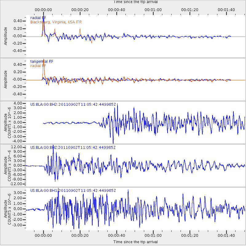
Earthquake location: Fox Islands, Aleutian Islands
Earthquake latitude/longitude: 52.2/-171.7
Earthquake time(UTC): 2011/09/02 (245) 10:55:53 GMT
Earthquake Depth: 32 km
Earthquake Magnitude: 6.5 MB, 6.9 MS, 6.8 MW, 6.8 MW
Earthquake Catalog/Contributor: WHDF/NEIC
Network: US United States National Seismic Network
Station: BLA Blacksburg, Virginia, USA
Lat/Lon: 37.21 N/80.42 W
Elevation: 634 m
Distance: 62.4 deg
Az: 64.25 deg
Baz: 315.987 deg
Ray Param: 0.060201935
Estimated Moho Depth: 23.5 km
Estimated Crust Vp/Vs: 1.98
Assumed Crust Vp: 6.159 km/s
Estimated Crust Vs: 3.107 km/s
Estimated Crust Poisson's Ratio: 0.33
Radial Match: 96.419426 %
Radial Bump: 400
Transverse Match: 90.279785 %
Transverse Bump: 400
SOD ConfigId: 558545
Insert Time: 2013-09-19 02:12:32.233 +0000
GWidth: 2.5
Max Bumps: 400
Tol: 0.001

Signal To Noise

ChannelStoNSTALTA
US:BLA:00:BHZ:20110902T11:05:42.449985Z27.947892.9801179E-61.0663123E-7
US:BLA:00:BH1:20110902T11:05:42.449985Z10.9254579.237279E-78.454821E-8
US:BLA:00:BH2:20110902T11:05:42.449985Z5.9178675.3464134E-79.034358E-8
Arrivals
Ps3.9 SECOND
PpPs11 SECOND
PsPs/PpSs15 SECOND