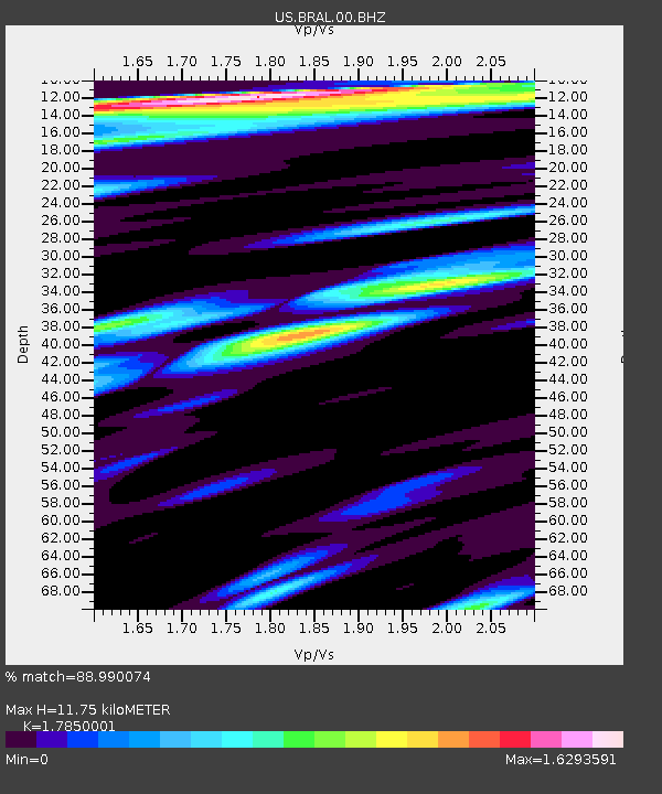
BRAL Brewton, Alabama, USA - Earthquake Result Viewer
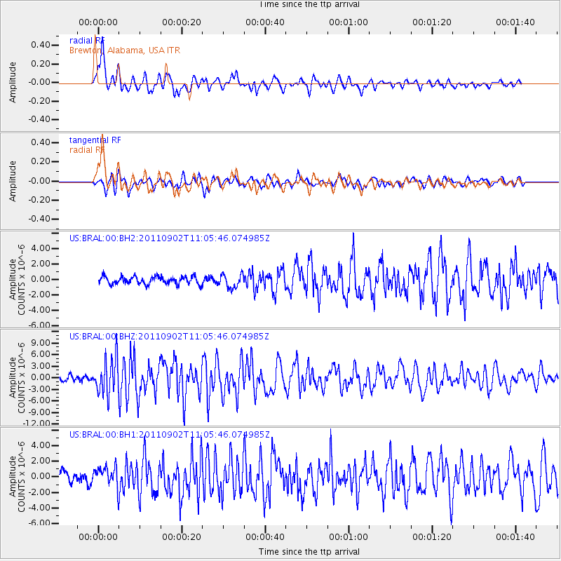
Earthquake location: Fox Islands, Aleutian Islands
Earthquake latitude/longitude: 52.2/-171.7
Earthquake time(UTC): 2011/09/02 (245) 10:55:53 GMT
Earthquake Depth: 32 km
Earthquake Magnitude: 6.5 MB, 6.9 MS, 6.8 MW, 6.8 MW
Earthquake Catalog/Contributor: WHDF/NEIC
Network: US United States National Seismic Network
Station: BRAL Brewton, Alabama, USA
Lat/Lon: 31.01 N/87.06 W
Elevation: 61 m
Distance: 63.1 deg
Az: 73.533 deg
Baz: 316.537 deg
Ray Param: 0.05977613
Estimated Moho Depth: 11.75 km
Estimated Crust Vp/Vs: 1.79
Assumed Crust Vp: 6.187 km/s
Estimated Crust Vs: 3.466 km/s
Estimated Crust Poisson's Ratio: 0.27
Radial Match: 88.990074 %
Radial Bump: 400
Transverse Match: 82.65419 %
Transverse Bump: 400
SOD ConfigId: 558545
Insert Time: 2013-09-19 02:12:43.044 +0000
GWidth: 2.5
Max Bumps: 400
Tol: 0.001

Signal To Noise

ChannelStoNSTALTA
US:BRAL:00:BHZ:20110902T11:05:46.074985Z7.04625754.79685E-66.807657E-7
US:BRAL:00:BH1:20110902T11:05:46.074985Z2.4517121.4055072E-65.732758E-7
US:BRAL:00:BH2:20110902T11:05:46.074985Z1.76059838.757693E-74.974271E-7
Arrivals
Ps1.6 SECOND
PpPs5.1 SECOND
PsPs/PpSs6.6 SECOND