You are here: Home > Network List > CN - Canadian National Seismograph Network Stations List
> Station INK INUVIK, NT, CANADA.ANADA > Earthquake Result Viewer
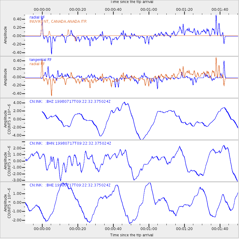
INK INUVIK, NT, CANADA.ANADA - Earthquake Result Viewer
*The percent match for this event was below the threshold and hence no stack was calculated.
| Earthquake location: |
Near N Coast Of New Guinea, P.N.G. |
| Earthquake latitude/longitude: |
-2.9/142.4 |
| Earthquake time(UTC): |
1998/07/17 (198) 09:10:02 GMT |
| Earthquake Depth: |
10 km |
| Earthquake Magnitude: |
5.9 MB |
| Earthquake Catalog/Contributor: |
WHDF/NEIC |
|
| Network: |
CN Canadian National Seismograph Network |
| Station: |
INK INUVIK, NT, CANADA.ANADA |
| Lat/Lon: |
68.31 N/133.52 W |
| Elevation: |
40 m |
|
| Distance: |
90.5 deg |
| Az: |
21.706 deg |
| Baz: |
263.481 deg |
| Ray Param: |
$rayparam |
*The percent match for this event was below the threshold and hence was not used in the summary stack. |
|
| Radial Match: |
39.10106 % |
| Radial Bump: |
400 |
| Transverse Match: |
55.783623 % |
| Transverse Bump: |
288 |
| SOD ConfigId: |
4480 |
| Insert Time: |
2010-02-27 06:22:16.354 +0000 |
| GWidth: |
2.5 |
| Max Bumps: |
400 |
| Tol: |
0.001 |
|
Signal To Noise
| Channel | StoN | STA | LTA |
| CN:INK: :BHN:19980717T09:22:32.375024Z | 1.2200682 | 8.7018634E-7 | 7.1322756E-7 |
| CN:INK: :BHE:19980717T09:22:32.375024Z | 1.8491644 | 1.7239304E-6 | 9.322753E-7 |
| CN:INK: :BHZ:19980717T09:22:32.375024Z | 3.0227146 | 3.1403383E-6 | 1.0389133E-6 |
| Arrivals |
| Ps | |
| PpPs | |
| PsPs/PpSs | |


