You are here: Home > Network List > US - United States National Seismic Network Stations List
> Station DGMT Dagmar, Montana, USA > Earthquake Result Viewer
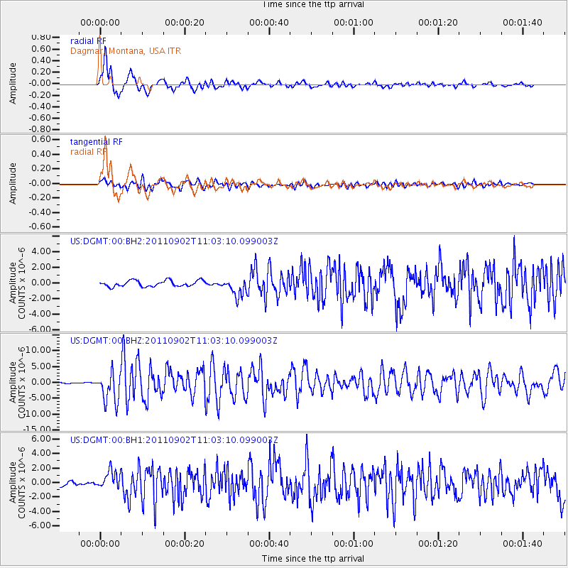
DGMT Dagmar, Montana, USA - Earthquake Result Viewer
*The percent match for this event was below the threshold and hence no stack was calculated.
| Earthquake location: |
Fox Islands, Aleutian Islands |
| Earthquake latitude/longitude: |
52.2/-171.7 |
| Earthquake time(UTC): |
2011/09/02 (245) 10:55:53 GMT |
| Earthquake Depth: |
32 km |
| Earthquake Magnitude: |
6.5 MB, 6.9 MS, 6.8 MW, 6.8 MW |
| Earthquake Catalog/Contributor: |
WHDF/NEIC |
|
| Network: |
US United States National Seismic Network |
| Station: |
DGMT Dagmar, Montana, USA |
| Lat/Lon: |
48.47 N/104.20 W |
| Elevation: |
0.0 m |
|
| Distance: |
41.9 deg |
| Az: |
67.147 deg |
| Baz: |
301.484 deg |
| Ray Param: |
$rayparam |
*The percent match for this event was below the threshold and hence was not used in the summary stack. |
|
| Radial Match: |
93.4827 % |
| Radial Bump: |
400 |
| Transverse Match: |
83.76729 % |
| Transverse Bump: |
400 |
| SOD ConfigId: |
558545 |
| Insert Time: |
2013-09-19 02:12:56.171 +0000 |
| GWidth: |
2.5 |
| Max Bumps: |
400 |
| Tol: |
0.001 |
|
Signal To Noise
| Channel | StoN | STA | LTA |
| US:DGMT:00:BHZ:20110902T11:03:10.099003Z | 24.758871 | 4.77637E-6 | 1.9291551E-7 |
| US:DGMT:00:BH1:20110902T11:03:10.099003Z | 5.009242 | 1.2830543E-6 | 2.561374E-7 |
| US:DGMT:00:BH2:20110902T11:03:10.099003Z | 3.2097018 | 1.2132643E-6 | 3.7799907E-7 |
| Arrivals |
| Ps | |
| PpPs | |
| PsPs/PpSs | |


