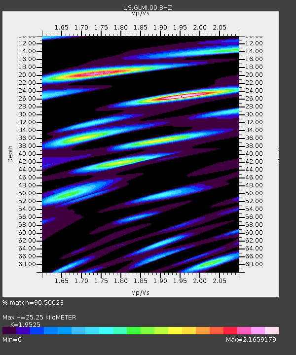
GLMI Grayling, Michigan, USA - Earthquake Result Viewer

Earthquake location: Fox Islands, Aleutian Islands
Earthquake latitude/longitude: 52.2/-171.7
Earthquake time(UTC): 2011/09/02 (245) 10:55:53 GMT
Earthquake Depth: 32 km
Earthquake Magnitude: 6.5 MB, 6.9 MS, 6.8 MW, 6.8 MW
Earthquake Catalog/Contributor: WHDF/NEIC
Network: US United States National Seismic Network
Station: GLMI Grayling, Michigan, USA
Lat/Lon: 44.82 N/84.62 W
Elevation: 387 m
Distance: 54.8 deg
Az: 60.37 deg
Baz: 311.212 deg
Ray Param: 0.06512693
Estimated Moho Depth: 25.25 km
Estimated Crust Vp/Vs: 1.95
Assumed Crust Vp: 6.483 km/s
Estimated Crust Vs: 3.32 km/s
Estimated Crust Poisson's Ratio: 0.32
Radial Match: 90.50023 %
Radial Bump: 400
Transverse Match: 87.25646 %
Transverse Bump: 400
SOD ConfigId: 558545
Insert Time: 2013-09-19 02:13:13.561 +0000
GWidth: 2.5
Max Bumps: 400
Tol: 0.001

Signal To Noise

ChannelStoNSTALTA
US:GLMI:00:BHZ:20110902T11:04:50.024021Z17.5116863.5025773E-62.000137E-7
US:GLMI:00:BH1:20110902T11:04:50.024021Z4.5368821.1308287E-62.4925237E-7
US:GLMI:00:BH2:20110902T11:04:50.024021Z4.5587491.3372473E-62.9333646E-7
Arrivals
Ps3.9 SECOND
PpPs11 SECOND
PsPs/PpSs15 SECOND