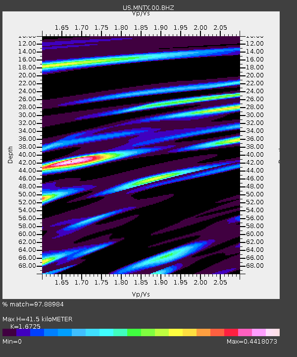
MNTX Cornudas Mountains, Texas, USA - Earthquake Result Viewer
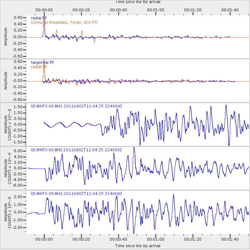
Earthquake location: Fox Islands, Aleutian Islands
Earthquake latitude/longitude: 52.2/-171.7
Earthquake time(UTC): 2011/09/02 (245) 10:55:53 GMT
Earthquake Depth: 32 km
Earthquake Magnitude: 6.5 MB, 6.9 MS, 6.8 MW, 6.8 MW
Earthquake Catalog/Contributor: WHDF/NEIC
Network: US United States National Seismic Network
Station: MNTX Cornudas Mountains, Texas, USA
Lat/Lon: 31.70 N/105.38 W
Elevation: 404 m
Distance: 51.5 deg
Az: 86.161 deg
Baz: 313.871 deg
Ray Param: 0.06732626
Estimated Moho Depth: 41.5 km
Estimated Crust Vp/Vs: 1.67
Assumed Crust Vp: 6.361 km/s
Estimated Crust Vs: 3.803 km/s
Estimated Crust Poisson's Ratio: 0.22
Radial Match: 97.88984 %
Radial Bump: 311
Transverse Match: 85.513596 %
Transverse Bump: 400
SOD ConfigId: 558545
Insert Time: 2013-09-19 02:14:04.930 +0000
GWidth: 2.5
Max Bumps: 400
Tol: 0.001

Signal To Noise

ChannelStoNSTALTA
US:MNTX:00:BHZ:20110902T11:04:25.324009Z20.3880792.2676234E-61.11223E-7
US:MNTX:00:BH1:20110902T11:04:25.324009Z10.1545331.0373457E-61.02155916E-7
US:MNTX:00:BH2:20110902T11:04:25.324009Z3.4555234.6825036E-71.355078E-7
Arrivals
Ps4.7 SECOND
PpPs16 SECOND
PsPs/PpSs21 SECOND