PKME Peaks-Kenny State Park, Maine, USA - Earthquake Result Viewer
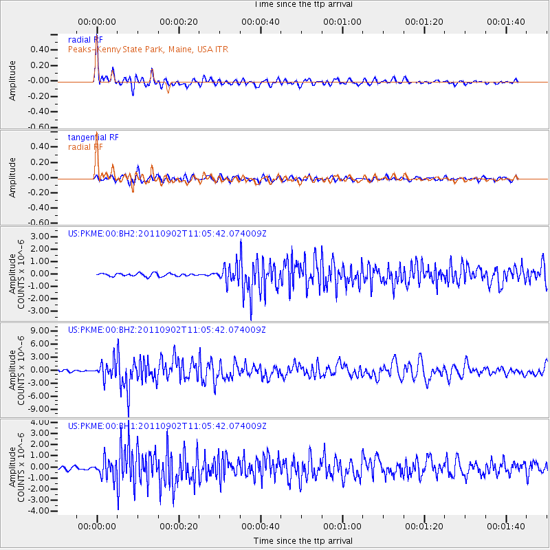
Earthquake location: Fox Islands, Aleutian Islands
Earthquake latitude/longitude: 52.2/-171.7
Earthquake time(UTC): 2011/09/02 (245) 10:55:53 GMT
Earthquake Depth: 32 km
Earthquake Magnitude: 6.5 MB, 6.9 MS, 6.8 MW, 6.8 MW
Earthquake Catalog/Contributor: WHDF/NEIC
Network: US United States National Seismic Network
Station: PKME Peaks-Kenny State Park, Maine, USA
Lat/Lon: 45.26 N/69.29 W
Elevation: 108 m
Distance: 62.3 deg
Az: 51.143 deg
Baz: 317.227 deg
Ray Param: 0.06024008
Estimated Moho Depth: 16.0 km
Estimated Crust Vp/Vs: 1.84
Assumed Crust Vp: 6.419 km/s
Estimated Crust Vs: 3.498 km/s
Estimated Crust Poisson's Ratio: 0.29
Radial Match: 89.06281 %
Radial Bump: 400
Transverse Match: 81.845085 %
Transverse Bump: 400
SOD ConfigId: 558545
Insert Time: 2013-09-19 02:14:27.956 +0000
GWidth: 2.5
Max Bumps: 400
Tol: 0.001

Signal To Noise

ChannelStoNSTALTA
US:PKME:00:BHZ:20110902T11:05:42.074009Z9.4533091.8141762E-61.9190914E-7
US:PKME:00:BH1:20110902T11:05:42.074009Z5.56047777.714875E-71.3874482E-7
US:PKME:00:BH2:20110902T11:05:42.074009Z5.33574446.258629E-71.1729627E-7
Arrivals
Ps2.2 SECOND
PpPs6.8 SECOND
PsPs/PpSs8.9 SECOND