You are here: Home > Network List > CN - Canadian National Seismograph Network Stations List
> Station INK INUVIK, NT, CANADA.ANADA > Earthquake Result Viewer
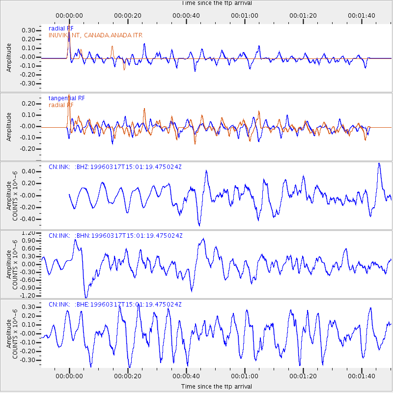
INK INUVIK, NT, CANADA.ANADA - Earthquake Result Viewer
*The percent match for this event was below the threshold and hence no stack was calculated.
| Earthquake location: |
Vanuatu Islands |
| Earthquake latitude/longitude: |
-14.7/167.3 |
| Earthquake time(UTC): |
1996/03/17 (077) 14:48:56 GMT |
| Earthquake Depth: |
164 km |
| Earthquake Magnitude: |
5.8 MB, 6.0 MS, 6.7 UNKNOWN, 6.1 MS |
| Earthquake Catalog/Contributor: |
WHDF/NEIC |
|
| Network: |
CN Canadian National Seismograph Network |
| Station: |
INK INUVIK, NT, CANADA.ANADA |
| Lat/Lon: |
68.31 N/133.52 W |
| Elevation: |
40 m |
|
| Distance: |
92.9 deg |
| Az: |
18.644 deg |
| Baz: |
236.312 deg |
| Ray Param: |
$rayparam |
*The percent match for this event was below the threshold and hence was not used in the summary stack. |
|
| Radial Match: |
55.389145 % |
| Radial Bump: |
400 |
| Transverse Match: |
55.76847 % |
| Transverse Bump: |
400 |
| SOD ConfigId: |
4480 |
| Insert Time: |
2010-02-27 06:22:27.624 +0000 |
| GWidth: |
2.5 |
| Max Bumps: |
400 |
| Tol: |
0.001 |
|
Signal To Noise
| Channel | StoN | STA | LTA |
| CN:INK: :BHN:19960317T15:01:19.475024Z | 2.8257706 | 5.527187E-7 | 1.9559928E-7 |
| CN:INK: :BHE:19960317T15:01:19.475024Z | 1.39329 | 1.5618987E-7 | 1.1210147E-7 |
| CN:INK: :BHZ:19960317T15:01:19.475024Z | 1.0948318 | 1.3921792E-7 | 1.2715917E-7 |
| Arrivals |
| Ps | |
| PpPs | |
| PsPs/PpSs | |


