You are here: Home > Network List > CU - Caribbean Network (USGS) Stations List
> Station GRGR Grenville, Grenada > Earthquake Result Viewer
GRGR Grenville, Grenada - Earthquake Result Viewer
| Earthquake location: |
Santiago Del Estero Prov., Arg. |
| Earthquake latitude/longitude: |
-28.4/-63.0 |
| Earthquake time(UTC): |
2011/09/02 (245) 13:47:09 GMT |
| Earthquake Depth: |
579 km |
| Earthquake Magnitude: |
6.4 MB, 6.7 MW, 6.7 MW |
| Earthquake Catalog/Contributor: |
WHDF/NEIC |
|
| Network: |
CU Caribbean Network (USGS) |
| Station: |
GRGR Grenville, Grenada |
| Lat/Lon: |
12.13 N/61.65 W |
| Elevation: |
195 m |
|
| Distance: |
40.3 deg |
| Az: |
2.079 deg |
| Baz: |
181.873 deg |
| Ray Param: |
0.07150607 |
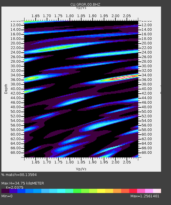
| Estimated Moho Depth: |
34.75 km |
| Estimated Crust Vp/Vs: |
2.04 |
| Assumed Crust Vp: |
5.738 km/s |
| Estimated Crust Vs: |
2.816 km/s |
| Estimated Crust Poisson's Ratio: |
0.34 |
|
| Radial Match: |
88.13594 % |
| Radial Bump: |
400 |
| Transverse Match: |
66.098045 % |
| Transverse Bump: |
400 |
| SOD ConfigId: |
558545 |
| Insert Time: |
2013-09-19 02:15:21.107 +0000 |
| GWidth: |
2.5 |
| Max Bumps: |
400 |
| Tol: |
0.001 |
|

Signal To Noise
| Channel | StoN | STA | LTA |
| CU:GRGR:00:BHZ:20110902T13:53:27.225011Z | 63.85245 | 1.9712004E-5 | 3.0871178E-7 |
| CU:GRGR:00:BH1:20110902T13:53:27.225011Z | 28.056713 | 1.0222941E-5 | 3.64367E-7 |
| CU:GRGR:00:BH2:20110902T13:53:27.225011Z | 11.311455 | 4.8230277E-6 | 4.263844E-7 |
| Arrivals |
| Ps | 6.6 SECOND |
| PpPs | 18 SECOND |
| PsPs/PpSs | 24 SECOND |


