You are here: Home > Network List > US - United States National Seismic Network Stations List
> Station AMTX Amarillo, Texas, USA > Earthquake Result Viewer
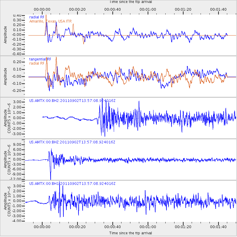
AMTX Amarillo, Texas, USA - Earthquake Result Viewer
*The percent match for this event was below the threshold and hence no stack was calculated.
| Earthquake location: |
Santiago Del Estero Prov., Arg. |
| Earthquake latitude/longitude: |
-28.4/-63.0 |
| Earthquake time(UTC): |
2011/09/02 (245) 13:47:09 GMT |
| Earthquake Depth: |
579 km |
| Earthquake Magnitude: |
6.4 MB, 6.7 MW, 6.7 MW |
| Earthquake Catalog/Contributor: |
WHDF/NEIC |
|
| Network: |
US United States National Seismic Network |
| Station: |
AMTX Amarillo, Texas, USA |
| Lat/Lon: |
34.53 N/101.41 W |
| Elevation: |
1010 m |
|
| Distance: |
72.3 deg |
| Az: |
327.458 deg |
| Baz: |
144.97 deg |
| Ray Param: |
$rayparam |
*The percent match for this event was below the threshold and hence was not used in the summary stack. |
|
| Radial Match: |
78.02718 % |
| Radial Bump: |
400 |
| Transverse Match: |
69.66384 % |
| Transverse Bump: |
400 |
| SOD ConfigId: |
558545 |
| Insert Time: |
2013-09-19 02:16:52.600 +0000 |
| GWidth: |
2.5 |
| Max Bumps: |
400 |
| Tol: |
0.001 |
|
Signal To Noise
| Channel | StoN | STA | LTA |
| US:AMTX:00:BHZ:20110902T13:57:08.924016Z | 8.153096 | 2.9074179E-6 | 3.5660292E-7 |
| US:AMTX:00:BH1:20110902T13:57:08.924016Z | 3.3912256 | 5.246453E-7 | 1.547067E-7 |
| US:AMTX:00:BH2:20110902T13:57:08.924016Z | 2.6848764 | 4.788783E-7 | 1.783614E-7 |
| Arrivals |
| Ps | |
| PpPs | |
| PsPs/PpSs | |


