You are here: Home > Network List > CN - Canadian National Seismograph Network Stations List
> Station INK INUVIK, NT, CANADA.ANADA > Earthquake Result Viewer
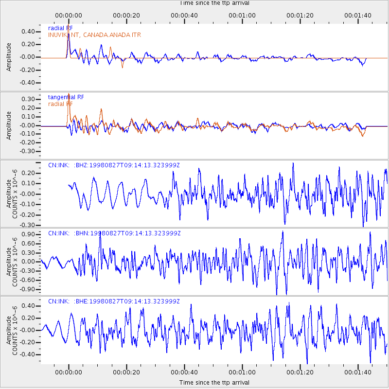
INK INUVIK, NT, CANADA.ANADA - Earthquake Result Viewer
*The percent match for this event was below the threshold and hence no stack was calculated.
| Earthquake location: |
Southern Xinjiang, China |
| Earthquake latitude/longitude: |
39.7/77.3 |
| Earthquake time(UTC): |
1998/08/27 (239) 09:03:36 GMT |
| Earthquake Depth: |
33 km |
| Earthquake Magnitude: |
5.6 MB, 6.4 MS, 6.3 UNKNOWN, 6.3 MW |
| Earthquake Catalog/Contributor: |
WHDF/NEIC |
|
| Network: |
CN Canadian National Seismograph Network |
| Station: |
INK INUVIK, NT, CANADA.ANADA |
| Lat/Lon: |
68.31 N/133.52 W |
| Elevation: |
40 m |
|
| Distance: |
69.9 deg |
| Az: |
11.718 deg |
| Baz: |
335.058 deg |
| Ray Param: |
$rayparam |
*The percent match for this event was below the threshold and hence was not used in the summary stack. |
|
| Radial Match: |
62.069935 % |
| Radial Bump: |
400 |
| Transverse Match: |
42.852142 % |
| Transverse Bump: |
400 |
| SOD ConfigId: |
4480 |
| Insert Time: |
2010-02-27 06:22:39.744 +0000 |
| GWidth: |
2.5 |
| Max Bumps: |
400 |
| Tol: |
0.001 |
|
Signal To Noise
| Channel | StoN | STA | LTA |
| CN:INK: :BHN:19980827T09:14:13.323999Z | 1.4889544 | 1.8736549E-7 | 1.2583695E-7 |
| CN:INK: :BHE:19980827T09:14:13.323999Z | 2.0693867 | 1.7323819E-7 | 8.371475E-8 |
| CN:INK: :BHZ:19980827T09:14:13.323999Z | 0.74203104 | 6.1044474E-8 | 8.226674E-8 |
| Arrivals |
| Ps | |
| PpPs | |
| PsPs/PpSs | |


