You are here: Home > Network List > US - United States National Seismic Network Stations List
> Station LRAL Lakeview Retreat, Alabama, USA > Earthquake Result Viewer
LRAL Lakeview Retreat, Alabama, USA - Earthquake Result Viewer
| Earthquake location: |
Santiago Del Estero Prov., Arg. |
| Earthquake latitude/longitude: |
-28.4/-63.0 |
| Earthquake time(UTC): |
2011/09/02 (245) 13:47:09 GMT |
| Earthquake Depth: |
579 km |
| Earthquake Magnitude: |
6.4 MB, 6.7 MW, 6.7 MW |
| Earthquake Catalog/Contributor: |
WHDF/NEIC |
|
| Network: |
US United States National Seismic Network |
| Station: |
LRAL Lakeview Retreat, Alabama, USA |
| Lat/Lon: |
33.03 N/87.00 W |
| Elevation: |
130 m |
|
| Distance: |
65.2 deg |
| Az: |
337.919 deg |
| Baz: |
156.78 deg |
| Ray Param: |
0.0562915 |
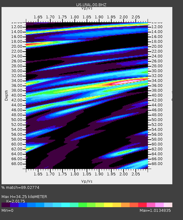
| Estimated Moho Depth: |
34.25 km |
| Estimated Crust Vp/Vs: |
2.02 |
| Assumed Crust Vp: |
6.565 km/s |
| Estimated Crust Vs: |
3.254 km/s |
| Estimated Crust Poisson's Ratio: |
0.34 |
|
| Radial Match: |
89.02774 % |
| Radial Bump: |
400 |
| Transverse Match: |
79.3438 % |
| Transverse Bump: |
400 |
| SOD ConfigId: |
558545 |
| Insert Time: |
2013-09-19 02:18:06.734 +0000 |
| GWidth: |
2.5 |
| Max Bumps: |
400 |
| Tol: |
0.001 |
|
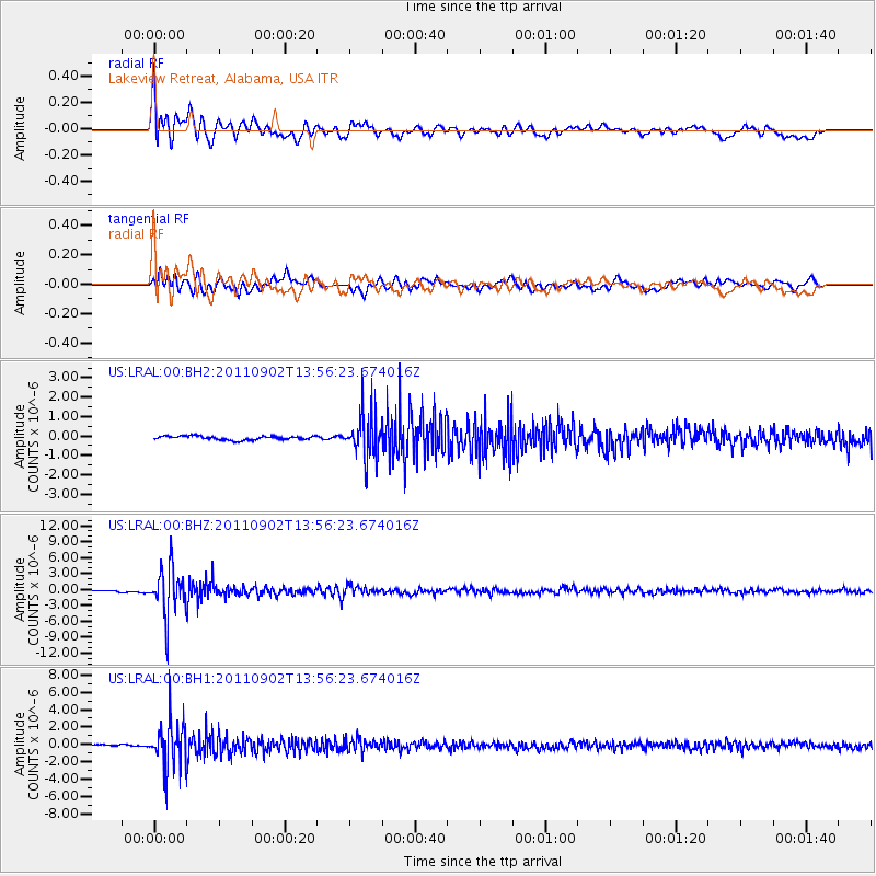
Signal To Noise
| Channel | StoN | STA | LTA |
| US:LRAL:00:BHZ:20110902T13:56:23.674016Z | 33.760223 | 4.5174525E-6 | 1.338099E-7 |
| US:LRAL:00:BH1:20110902T13:56:23.674016Z | 23.285145 | 2.5439076E-6 | 1.0925024E-7 |
| US:LRAL:00:BH2:20110902T13:56:23.674016Z | 12.035102 | 1.1488133E-6 | 9.545523E-8 |
| Arrivals |
| Ps | 5.5 SECOND |
| PpPs | 15 SECOND |
| PsPs/PpSs | 21 SECOND |


