You are here: Home > Network List > CN - Canadian National Seismograph Network Stations List
> Station INK INUVIK, NT, CANADA.ANADA > Earthquake Result Viewer
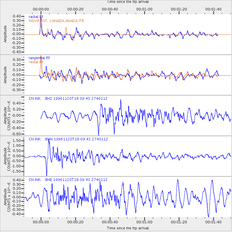
INK INUVIK, NT, CANADA.ANADA - Earthquake Result Viewer
*The percent match for this event was below the threshold and hence no stack was calculated.
| Earthquake location: |
Luzon, Philippines |
| Earthquake latitude/longitude: |
16.3/120.5 |
| Earthquake time(UTC): |
1996/11/20 (325) 17:58:04 GMT |
| Earthquake Depth: |
33 km |
| Earthquake Magnitude: |
5.7 MB, 5.7 MS, 6.0 UNKNOWN, 5.9 MW |
| Earthquake Catalog/Contributor: |
WHDF/NEIC |
|
| Network: |
CN Canadian National Seismograph Network |
| Station: |
INK INUVIK, NT, CANADA.ANADA |
| Lat/Lon: |
68.31 N/133.52 W |
| Elevation: |
40 m |
|
| Distance: |
80.7 deg |
| Az: |
21.237 deg |
| Baz: |
290.708 deg |
| Ray Param: |
$rayparam |
*The percent match for this event was below the threshold and hence was not used in the summary stack. |
|
| Radial Match: |
70.85707 % |
| Radial Bump: |
320 |
| Transverse Match: |
57.3011 % |
| Transverse Bump: |
400 |
| SOD ConfigId: |
4480 |
| Insert Time: |
2010-02-27 06:22:53.440 +0000 |
| GWidth: |
2.5 |
| Max Bumps: |
400 |
| Tol: |
0.001 |
|
Signal To Noise
| Channel | StoN | STA | LTA |
| CN:INK: :BHN:19961120T18:09:43.274011Z | 7.3650455 | 7.153309E-7 | 9.712512E-8 |
| CN:INK: :BHE:19961120T18:09:43.274011Z | 2.0518293 | 1.8080993E-7 | 8.812133E-8 |
| CN:INK: :BHZ:19961120T18:09:43.274011Z | 2.5534446 | 2.3065483E-7 | 9.033085E-8 |
| Arrivals |
| Ps | |
| PpPs | |
| PsPs/PpSs | |


