You are here: Home > Network List > IU - Global Seismograph Network (GSN - IRIS/USGS) Stations List
> Station OTAV Otavalo, Ecuador > Earthquake Result Viewer
OTAV Otavalo, Ecuador - Earthquake Result Viewer
| Earthquake location: |
South Sandwich Islands Region |
| Earthquake latitude/longitude: |
-56.5/-26.8 |
| Earthquake time(UTC): |
2011/09/03 (246) 04:48:57 GMT |
| Earthquake Depth: |
84 km |
| Earthquake Magnitude: |
6.1 MB, 6.4 MW, 6.4 MW |
| Earthquake Catalog/Contributor: |
WHDF/NEIC |
|
| Network: |
IU Global Seismograph Network (GSN - IRIS/USGS) |
| Station: |
OTAV Otavalo, Ecuador |
| Lat/Lon: |
0.24 N/78.45 W |
| Elevation: |
3510 m |
|
| Distance: |
70.0 deg |
| Az: |
303.506 deg |
| Baz: |
152.421 deg |
| Ray Param: |
0.05504709 |
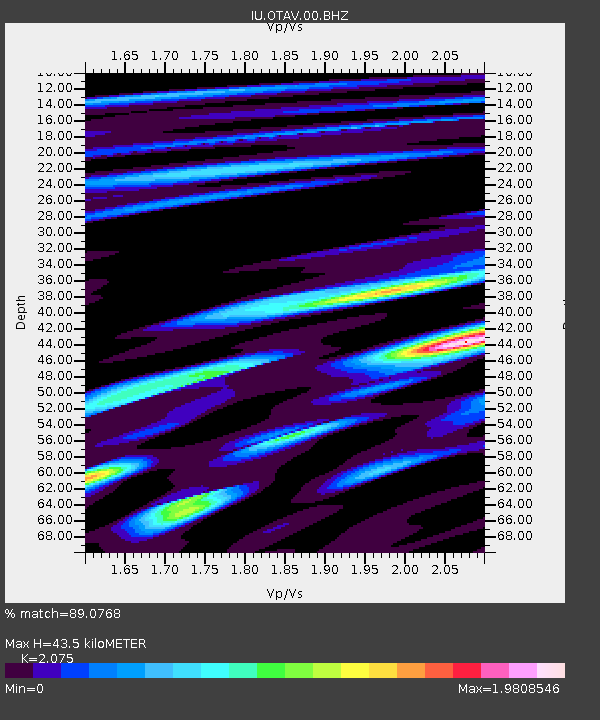
| Estimated Moho Depth: |
43.5 km |
| Estimated Crust Vp/Vs: |
2.08 |
| Assumed Crust Vp: |
6.472 km/s |
| Estimated Crust Vs: |
3.119 km/s |
| Estimated Crust Poisson's Ratio: |
0.35 |
|
| Radial Match: |
89.0768 % |
| Radial Bump: |
400 |
| Transverse Match: |
79.99376 % |
| Transverse Bump: |
400 |
| SOD ConfigId: |
558545 |
| Insert Time: |
2013-09-19 02:21:59.768 +0000 |
| GWidth: |
2.5 |
| Max Bumps: |
400 |
| Tol: |
0.001 |
|
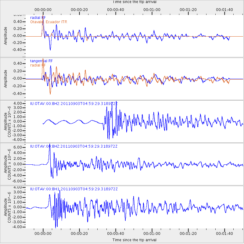
Signal To Noise
| Channel | StoN | STA | LTA |
| IU:OTAV:00:BHZ:20110903T04:59:29.318972Z | 23.74864 | 2.408745E-6 | 1.0142666E-7 |
| IU:OTAV:00:BH1:20110903T04:59:29.318972Z | 4.155764 | 9.282639E-7 | 2.233678E-7 |
| IU:OTAV:00:BH2:20110903T04:59:29.318972Z | 2.1387706 | 6.259803E-7 | 2.926823E-7 |
| Arrivals |
| Ps | 7.5 SECOND |
| PpPs | 20 SECOND |
| PsPs/PpSs | 27 SECOND |


