You are here: Home > Network List > IU - Global Seismograph Network (GSN - IRIS/USGS) Stations List
> Station JOHN Johnston Island, USA > Earthquake Result Viewer
JOHN Johnston Island, USA - Earthquake Result Viewer
| Earthquake location: |
Vanuatu Islands |
| Earthquake latitude/longitude: |
-20.7/169.7 |
| Earthquake time(UTC): |
2011/09/03 (246) 22:55:40 GMT |
| Earthquake Depth: |
185 km |
| Earthquake Magnitude: |
6.4 MB, 7.0 MW, 7.0 MW |
| Earthquake Catalog/Contributor: |
WHDF/NEIC |
|
| Network: |
IU Global Seismograph Network (GSN - IRIS/USGS) |
| Station: |
JOHN Johnston Island, USA |
| Lat/Lon: |
16.73 N/169.53 W |
| Elevation: |
2.0 m |
|
| Distance: |
42.4 deg |
| Az: |
30.244 deg |
| Baz: |
209.487 deg |
| Ray Param: |
0.07249762 |
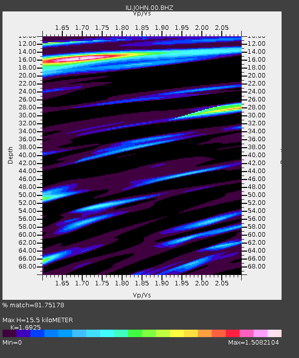
| Estimated Moho Depth: |
15.5 km |
| Estimated Crust Vp/Vs: |
1.69 |
| Assumed Crust Vp: |
4.24 km/s |
| Estimated Crust Vs: |
2.505 km/s |
| Estimated Crust Poisson's Ratio: |
0.23 |
|
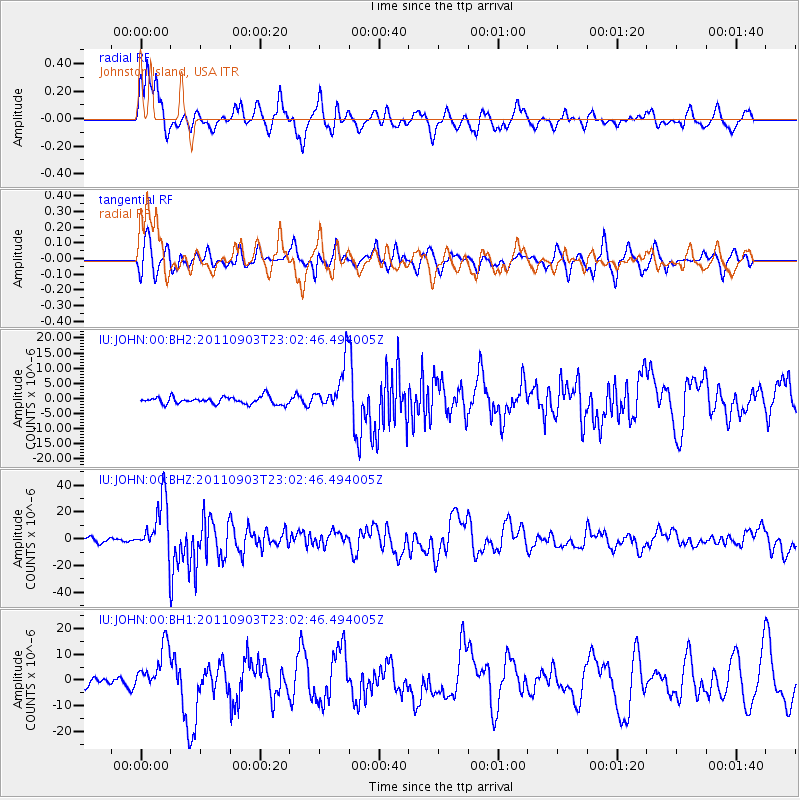
| Radial Match: |
81.75178 % |
| Radial Bump: |
400 |
| Transverse Match: |
75.54967 % |
| Transverse Bump: |
400 |
| SOD ConfigId: |
558545 |
| Insert Time: |
2013-09-19 02:25:35.670 +0000 |
| GWidth: |
2.5 |
| Max Bumps: |
400 |
| Tol: |
0.001 |
|
Signal To Noise
| Channel | StoN | STA | LTA |
| IU:JOHN:00:BHZ:20110903T23:02:46.494005Z | 14.622234 | 2.0658721E-5 | 1.4128292E-6 |
| IU:JOHN:00:BH1:20110903T23:02:46.494005Z | 6.5067005 | 8.8415745E-6 | 1.3588415E-6 |
| IU:JOHN:00:BH2:20110903T23:02:46.494005Z | 6.5003138 | 7.741057E-6 | 1.1908744E-6 |
| Arrivals |
| Ps | 2.6 SECOND |
| PpPs | 9.6 SECOND |
| PsPs/PpSs | 12 SECOND |


