QSPA South Pole Remote Earth Science Observatory (Quiet Zone) - Earthquake Result Viewer
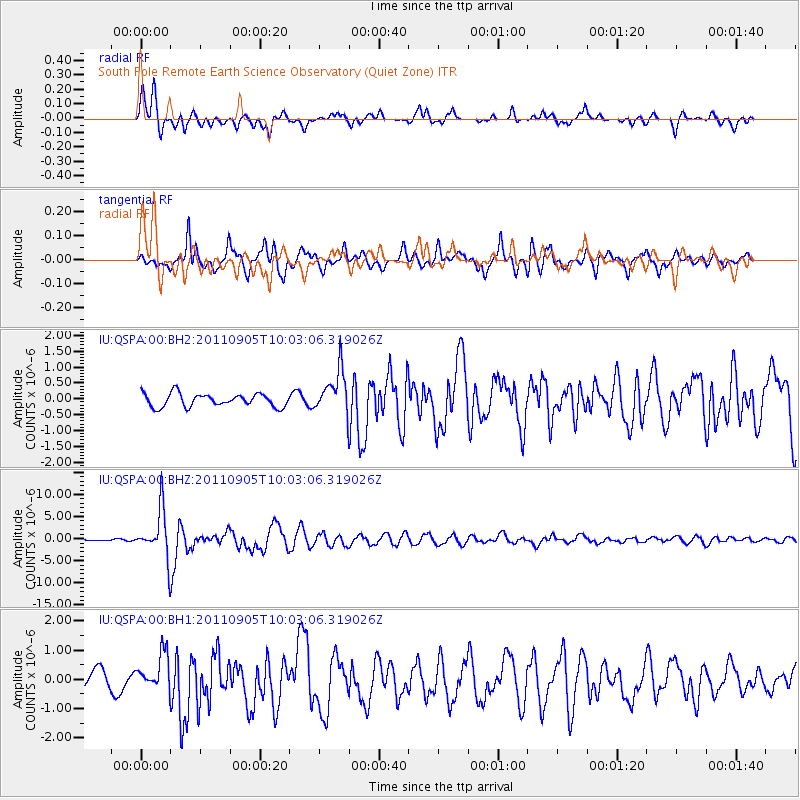
Earthquake location: Tonga Islands
Earthquake latitude/longitude: -15.3/-173.6
Earthquake time(UTC): 2011/09/05 (248) 09:52:01 GMT
Earthquake Depth: 37 km
Earthquake Magnitude: 6.2 MB, 6.2 MS, 6.3 MW, 6.2 MW
Earthquake Catalog/Contributor: WHDF/NEIC
Network: IU Global Seismograph Network (GSN - IRIS/USGS)
Station: QSPA South Pole Remote Earth Science Observatory (Quiet Zone)
Lat/Lon: 89.93 S/144.44 E
Elevation: 2850 m
Distance: 74.7 deg
Az: 180.05 deg
Baz: 41.954 deg
Ray Param: 0.05206633
Estimated Moho Depth: 21.25 km
Estimated Crust Vp/Vs: 1.61
Assumed Crust Vp: 6.193 km/s
Estimated Crust Vs: 3.847 km/s
Estimated Crust Poisson's Ratio: 0.19
Radial Match: 89.325226 %
Radial Bump: 400
Transverse Match: 87.93595 %
Transverse Bump: 400
SOD ConfigId: 558545
Insert Time: 2013-09-19 02:29:30.515 +0000
GWidth: 2.5
Max Bumps: 400
Tol: 0.001

Signal To Noise

ChannelStoNSTALTA
IU:QSPA:00:BHZ:20110905T10:03:06.319026Z34.8236165.380392E-61.5450412E-7
IU:QSPA:00:BH1:20110905T10:03:06.319026Z2.47941786.3943287E-72.5789637E-7
IU:QSPA:00:BH2:20110905T10:03:06.319026Z3.30050686.792324E-72.057964E-7
Arrivals
Ps2.2 SECOND
PpPs8.7 SECOND
PsPs/PpSs11 SECOND