You are here: Home > Network List > US - United States National Seismic Network Stations List
> Station NATX Nacogdoches, Texas, USA > Earthquake Result Viewer
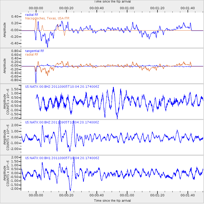
NATX Nacogdoches, Texas, USA - Earthquake Result Viewer
*The percent match for this event was below the threshold and hence no stack was calculated.
| Earthquake location: |
Tonga Islands |
| Earthquake latitude/longitude: |
-15.3/-173.6 |
| Earthquake time(UTC): |
2011/09/05 (248) 09:52:01 GMT |
| Earthquake Depth: |
37 km |
| Earthquake Magnitude: |
6.2 MB, 6.2 MS, 6.3 MW, 6.2 MW |
| Earthquake Catalog/Contributor: |
WHDF/NEIC |
|
| Network: |
US United States National Seismic Network |
| Station: |
NATX Nacogdoches, Texas, USA |
| Lat/Lon: |
31.76 N/94.66 W |
| Elevation: |
156 m |
|
| Distance: |
88.8 deg |
| Az: |
56.746 deg |
| Baz: |
251.327 deg |
| Ray Param: |
$rayparam |
*The percent match for this event was below the threshold and hence was not used in the summary stack. |
|
| Radial Match: |
62.425358 % |
| Radial Bump: |
400 |
| Transverse Match: |
96.431526 % |
| Transverse Bump: |
216 |
| SOD ConfigId: |
558545 |
| Insert Time: |
2013-09-19 02:30:47.028 +0000 |
| GWidth: |
2.5 |
| Max Bumps: |
400 |
| Tol: |
0.001 |
|
Signal To Noise
| Channel | StoN | STA | LTA |
| US:NATX:00:BHZ:20110905T10:04:20.174006Z | 2.8241246 | 9.029441E-7 | 3.1972533E-7 |
| US:NATX:00:BH1:20110905T10:04:20.174006Z | 2.013158 | 5.641001E-7 | 2.8020656E-7 |
| US:NATX:00:BH2:20110905T10:04:20.174006Z | 0.84505856 | 4.6886765E-7 | 5.548345E-7 |
| Arrivals |
| Ps | |
| PpPs | |
| PsPs/PpSs | |


