You are here: Home > Network List > US - United States National Seismic Network Stations List
> Station CBKS Cedar Bluff, Kansas, USA > Earthquake Result Viewer
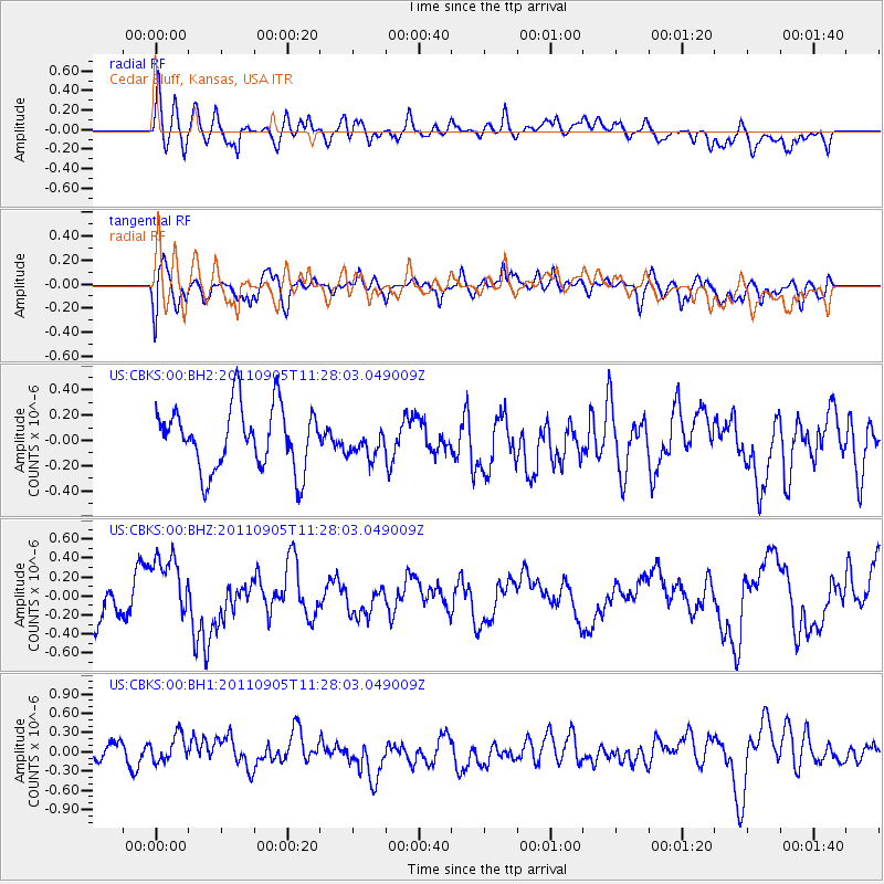
CBKS Cedar Bluff, Kansas, USA - Earthquake Result Viewer
*The percent match for this event was below the threshold and hence no stack was calculated.
| Earthquake location: |
South Of Panama |
| Earthquake latitude/longitude: |
6.6/-82.4 |
| Earthquake time(UTC): |
2011/09/05 (248) 11:21:36 GMT |
| Earthquake Depth: |
25 km |
| Earthquake Magnitude: |
5.8 MW, 5.2 MS, 5.3 MB, 5.8 MW |
| Earthquake Catalog/Contributor: |
WHDF/NEIC |
|
| Network: |
US United States National Seismic Network |
| Station: |
CBKS Cedar Bluff, Kansas, USA |
| Lat/Lon: |
38.81 N/99.74 W |
| Elevation: |
677 m |
|
| Distance: |
35.7 deg |
| Az: |
336.455 deg |
| Baz: |
149.468 deg |
| Ray Param: |
$rayparam |
*The percent match for this event was below the threshold and hence was not used in the summary stack. |
|
| Radial Match: |
56.352676 % |
| Radial Bump: |
400 |
| Transverse Match: |
49.402275 % |
| Transverse Bump: |
400 |
| SOD ConfigId: |
558545 |
| Insert Time: |
2013-09-19 02:32:13.484 +0000 |
| GWidth: |
2.5 |
| Max Bumps: |
400 |
| Tol: |
0.001 |
|
Signal To Noise
| Channel | StoN | STA | LTA |
| US:CBKS:00:BHZ:20110905T11:28:03.049009Z | 1.708936 | 3.5634378E-7 | 2.085179E-7 |
| US:CBKS:00:BH1:20110905T11:28:03.049009Z | 1.3657837 | 2.258287E-7 | 1.6534733E-7 |
| US:CBKS:00:BH2:20110905T11:28:03.049009Z | 0.45543993 | 1.12466765E-7 | 2.4694097E-7 |
| Arrivals |
| Ps | |
| PpPs | |
| PsPs/PpSs | |


