You are here: Home > Network List > II - Global Seismograph Network (GSN - IRIS/IDA) Stations List
> Station ABPO Ambohimpanompo, Madagascar > Earthquake Result Viewer
ABPO Ambohimpanompo, Madagascar - Earthquake Result Viewer

| Earthquake location: |
Northern Sumatra, Indonesia |
| Earthquake latitude/longitude: |
3.0/97.9 |
| Earthquake time(UTC): |
2011/09/05 (248) 17:55:11 GMT |
| Earthquake Depth: |
91 km |
| Earthquake Magnitude: |
6.6 MB, 6.7 MW, 6.7 MW |
| Earthquake Catalog/Contributor: |
WHDF/NEIC |
|
| Network: |
II Global Seismograph Network (GSN - IRIS/IDA) |
| Station: |
ABPO Ambohimpanompo, Madagascar |
| Lat/Lon: |
19.02 S/47.23 E |
| Elevation: |
1528 m |
|
| Distance: |
54.4 deg |
| Az: |
244.165 deg |
| Baz: |
71.82 deg |
| Ray Param: |
0.065211825 |
| Estimated Moho Depth: |
40.75 km |
| Estimated Crust Vp/Vs: |
1.60 |
| Assumed Crust Vp: |
6.642 km/s |
| Estimated Crust Vs: |
4.145 km/s |
| Estimated Crust Poisson's Ratio: |
0.18 |
|
| Radial Match: |
94.54717 % |
| Radial Bump: |
295 |
| Transverse Match: |
80.30621 % |
| Transverse Bump: |
400 |
| SOD ConfigId: |
558545 |
| Insert Time: |
2013-09-19 02:33:20.562 +0000 |
| GWidth: |
2.5 |
| Max Bumps: |
400 |
| Tol: |
0.001 |
|
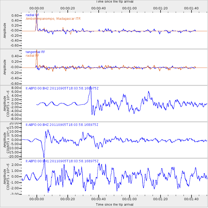
Signal To Noise
| Channel | StoN | STA | LTA |
| II:ABPO:00:BHZ:20110905T18:03:58.168975Z | 7.7159014 | 7.714381E-6 | 9.99803E-7 |
| II:ABPO:00:BH1:20110905T18:03:58.168975Z | 1.6394173 | 9.4322667E-7 | 5.753426E-7 |
| II:ABPO:00:BH2:20110905T18:03:58.168975Z | 5.7599707 | 3.3019824E-6 | 5.732637E-7 |
| Arrivals |
| Ps | 3.9 SECOND |
| PpPs | 15 SECOND |
| PsPs/PpSs | 19 SECOND |


