You are here: Home > Network List > CN - Canadian National Seismograph Network Stations List
> Station INK INUVIK, NT, CANADA.ANADA > Earthquake Result Viewer
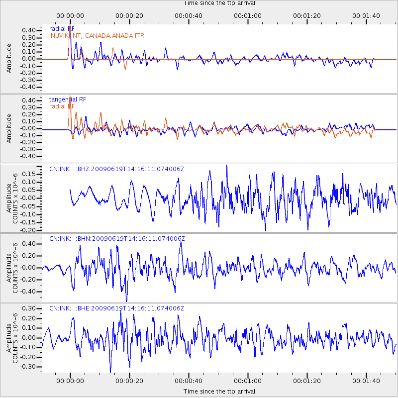
INK INUVIK, NT, CANADA.ANADA - Earthquake Result Viewer
*The percent match for this event was below the threshold and hence no stack was calculated.
| Earthquake location: |
Eastern Mediterranean Sea |
| Earthquake latitude/longitude: |
35.4/28.5 |
| Earthquake time(UTC): |
2009/06/19 (170) 14:04:59 GMT |
| Earthquake Depth: |
28 km |
| Earthquake Magnitude: |
5.6 MB, 5.6 MS, 5.8 MW, 5.8 MW |
| Earthquake Catalog/Contributor: |
WHDF/NEIC |
|
| Network: |
CN Canadian National Seismograph Network |
| Station: |
INK INUVIK, NT, CANADA.ANADA |
| Lat/Lon: |
68.31 N/133.52 W |
| Elevation: |
40 m |
|
| Distance: |
75.8 deg |
| Az: |
353.183 deg |
| Baz: |
15.127 deg |
| Ray Param: |
$rayparam |
*The percent match for this event was below the threshold and hence was not used in the summary stack. |
|
| Radial Match: |
61.60164 % |
| Radial Bump: |
400 |
| Transverse Match: |
50.732452 % |
| Transverse Bump: |
400 |
| SOD ConfigId: |
2648 |
| Insert Time: |
2010-02-27 06:23:32.618 +0000 |
| GWidth: |
2.5 |
| Max Bumps: |
400 |
| Tol: |
0.001 |
|
Signal To Noise
| Channel | StoN | STA | LTA |
| CN:INK: :BHN:20090619T14:16:11.074006Z | 3.2221887 | 1.8868066E-7 | 5.8556672E-8 |
| CN:INK: :BHE:20090619T14:16:11.074006Z | 2.3225756 | 1.1256479E-7 | 4.8465502E-8 |
| CN:INK: :BHZ:20090619T14:16:11.074006Z | 1.0200788 | 4.575193E-8 | 4.4851365E-8 |
| Arrivals |
| Ps | |
| PpPs | |
| PsPs/PpSs | |


