You are here: Home > Network List > US - United States National Seismic Network Stations List
> Station MSO Missoula, Montana, USA > Earthquake Result Viewer
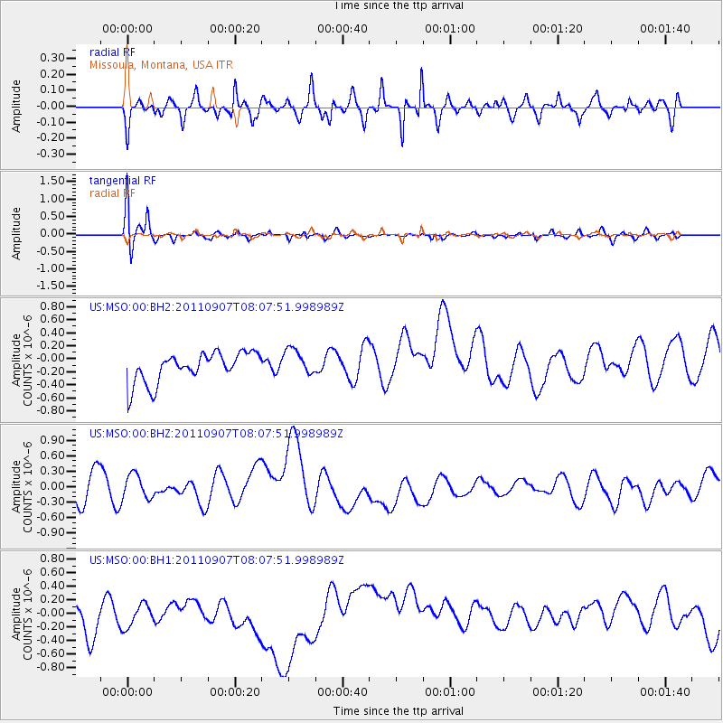
MSO Missoula, Montana, USA - Earthquake Result Viewer
*The percent match for this event was below the threshold and hence no stack was calculated.
| Earthquake location: |
Kermadec Islands Region |
| Earthquake latitude/longitude: |
-27.8/-178.5 |
| Earthquake time(UTC): |
2011/09/07 (250) 07:55:32 GMT |
| Earthquake Depth: |
252 km |
| Earthquake Magnitude: |
5.5 MW |
| Earthquake Catalog/Contributor: |
NEIC PDE/NEIC PDE-M |
|
| Network: |
US United States National Seismic Network |
| Station: |
MSO Missoula, Montana, USA |
| Lat/Lon: |
46.83 N/113.94 W |
| Elevation: |
1264 m |
|
| Distance: |
94.3 deg |
| Az: |
38.433 deg |
| Baz: |
233.34 deg |
| Ray Param: |
$rayparam |
*The percent match for this event was below the threshold and hence was not used in the summary stack. |
|
| Radial Match: |
70.69128 % |
| Radial Bump: |
400 |
| Transverse Match: |
87.17235 % |
| Transverse Bump: |
400 |
| SOD ConfigId: |
558545 |
| Insert Time: |
2013-09-19 02:36:04.670 +0000 |
| GWidth: |
2.5 |
| Max Bumps: |
400 |
| Tol: |
0.001 |
|
Signal To Noise
| Channel | StoN | STA | LTA |
| US:MSO:00:BHZ:20110907T08:07:51.998989Z | 0.81759006 | 2.9828638E-7 | 3.6483613E-7 |
| US:MSO:00:BH1:20110907T08:07:51.998989Z | 0.6303262 | 2.421192E-7 | 3.8411727E-7 |
| US:MSO:00:BH2:20110907T08:07:51.998989Z | 0.91308236 | 2.0990639E-7 | 2.2988769E-7 |
| Arrivals |
| Ps | |
| PpPs | |
| PsPs/PpSs | |


