You are here: Home > Network List > IU - Global Seismograph Network (GSN - IRIS/USGS) Stations List
> Station JOHN Johnston Island, USA > Earthquake Result Viewer
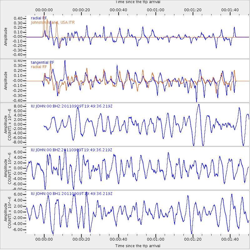
JOHN Johnston Island, USA - Earthquake Result Viewer
*The percent match for this event was below the threshold and hence no stack was calculated.
| Earthquake location: |
Vancouver Island, Canada Region |
| Earthquake latitude/longitude: |
49.5/-126.9 |
| Earthquake time(UTC): |
2011/09/09 (252) 19:41:34 GMT |
| Earthquake Depth: |
22 km |
| Earthquake Magnitude: |
6.3 MB, 6.4 MS, 6.4 MW, 6.5 MW |
| Earthquake Catalog/Contributor: |
WHDF/NEIC |
|
| Network: |
IU Global Seismograph Network (GSN - IRIS/USGS) |
| Station: |
JOHN Johnston Island, USA |
| Lat/Lon: |
16.73 N/169.53 W |
| Elevation: |
2.0 m |
|
| Distance: |
47.4 deg |
| Az: |
241.776 deg |
| Baz: |
36.805 deg |
| Ray Param: |
$rayparam |
*The percent match for this event was below the threshold and hence was not used in the summary stack. |
|
| Radial Match: |
47.15327 % |
| Radial Bump: |
334 |
| Transverse Match: |
56.77945 % |
| Transverse Bump: |
349 |
| SOD ConfigId: |
558545 |
| Insert Time: |
2013-09-19 02:38:10.510 +0000 |
| GWidth: |
2.5 |
| Max Bumps: |
400 |
| Tol: |
0.001 |
|
Signal To Noise
| Channel | StoN | STA | LTA |
| IU:JOHN:00:BHZ:20110909T19:49:36.219Z | 2.4230306 | 3.922212E-6 | 1.6187214E-6 |
| IU:JOHN:00:BH1:20110909T19:49:36.219Z | 2.6252427 | 4.0735767E-6 | 1.5516954E-6 |
| IU:JOHN:00:BH2:20110909T19:49:36.219Z | 1.0192826 | 3.1547045E-6 | 3.0950243E-6 |
| Arrivals |
| Ps | |
| PpPs | |
| PsPs/PpSs | |


