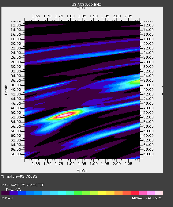
ACSO Alum Creek State Park, Ohio, USA - Earthquake Result Viewer
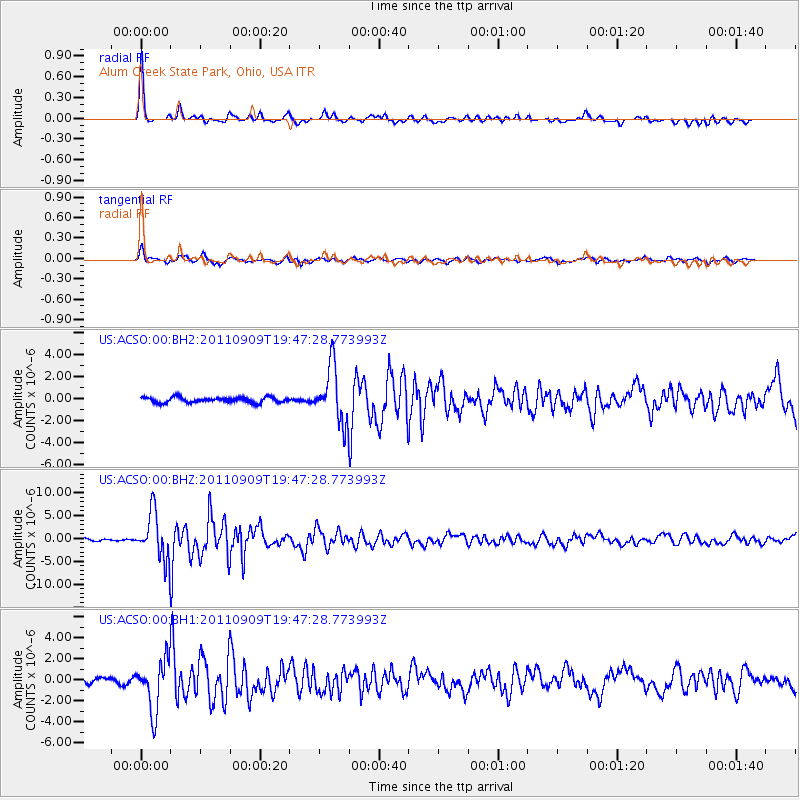
Earthquake location: Vancouver Island, Canada Region
Earthquake latitude/longitude: 49.5/-126.9
Earthquake time(UTC): 2011/09/09 (252) 19:41:34 GMT
Earthquake Depth: 22 km
Earthquake Magnitude: 6.3 MB, 6.4 MS, 6.4 MW, 6.5 MW
Earthquake Catalog/Contributor: WHDF/NEIC
Network: US United States National Seismic Network
Station: ACSO Alum Creek State Park, Ohio, USA
Lat/Lon: 40.23 N/82.98 W
Elevation: 288 m
Distance: 32.1 deg
Az: 89.921 deg
Baz: 301.679 deg
Ray Param: 0.07878391
Estimated Moho Depth: 50.75 km
Estimated Crust Vp/Vs: 1.77
Assumed Crust Vp: 6.498 km/s
Estimated Crust Vs: 3.661 km/s
Estimated Crust Poisson's Ratio: 0.27
Radial Match: 92.70085 %
Radial Bump: 337
Transverse Match: 84.98312 %
Transverse Bump: 400
SOD ConfigId: 558545
Insert Time: 2013-09-19 02:39:07.807 +0000
GWidth: 2.5
Max Bumps: 400
Tol: 0.001

Signal To Noise

ChannelStoNSTALTA
US:ACSO:00:BHZ:20110909T19:47:28.773993Z16.9548575.028342E-62.9657235E-7
US:ACSO:00:BH1:20110909T19:47:28.773993Z8.7565462.3765217E-62.7139947E-7
US:ACSO:00:BH2:20110909T19:47:28.773993Z10.4552742.4732421E-62.365545E-7
Arrivals
Ps6.6 SECOND
PpPs20 SECOND
PsPs/PpSs27 SECOND