BRAL Brewton, Alabama, USA - Earthquake Result Viewer
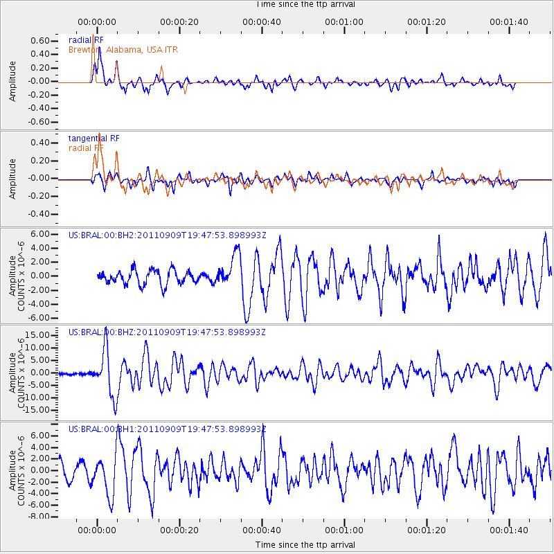
Earthquake location: Vancouver Island, Canada Region
Earthquake latitude/longitude: 49.5/-126.9
Earthquake time(UTC): 2011/09/09 (252) 19:41:34 GMT
Earthquake Depth: 22 km
Earthquake Magnitude: 6.3 MB, 6.4 MS, 6.4 MW, 6.5 MW
Earthquake Catalog/Contributor: WHDF/NEIC
Network: US United States National Seismic Network
Station: BRAL Brewton, Alabama, USA
Lat/Lon: 31.01 N/87.06 W
Elevation: 61 m
Distance: 35.1 deg
Az: 106.81 deg
Baz: 313.416 deg
Ray Param: 0.07738667
Estimated Moho Depth: 14.25 km
Estimated Crust Vp/Vs: 1.60
Assumed Crust Vp: 6.187 km/s
Estimated Crust Vs: 3.867 km/s
Estimated Crust Poisson's Ratio: 0.18
Radial Match: 85.3446 %
Radial Bump: 400
Transverse Match: 75.26829 %
Transverse Bump: 400
SOD ConfigId: 558545
Insert Time: 2013-09-19 02:39:16.835 +0000
GWidth: 2.5
Max Bumps: 400
Tol: 0.001

Signal To Noise

ChannelStoNSTALTA
US:BRAL:00:BHZ:20110909T19:47:53.898993Z20.557579.749501E-64.742536E-7
US:BRAL:00:BH1:20110909T19:47:53.898993Z3.82124733.6668462E-69.59594E-7
US:BRAL:00:BH2:20110909T19:47:53.898993Z2.73445152.6749913E-69.782551E-7
Arrivals
Ps1.5 SECOND
PpPs5.5 SECOND
PsPs/PpSs7.0 SECOND