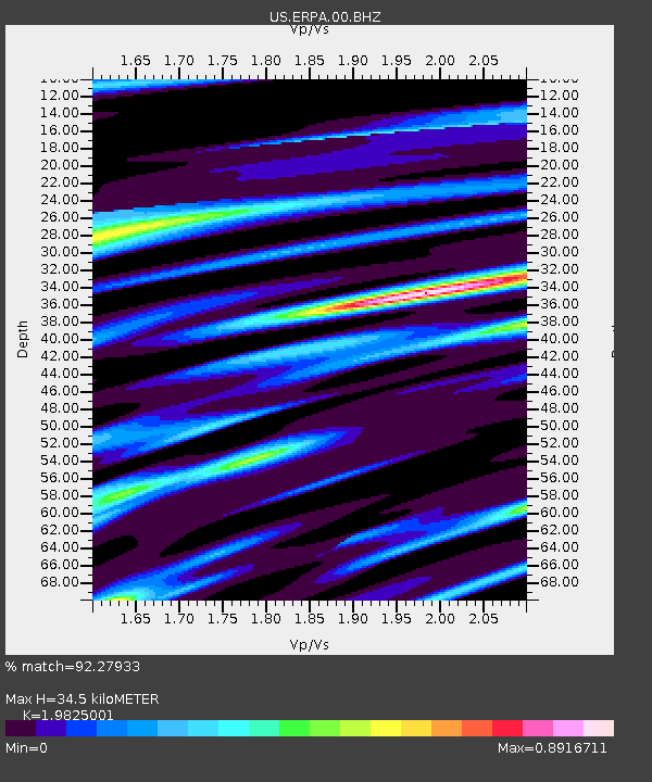
ERPA Erie, Pennsylvania, USA - Earthquake Result Viewer
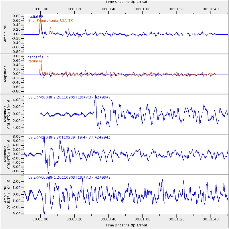
Earthquake location: Vancouver Island, Canada Region
Earthquake latitude/longitude: 49.5/-126.9
Earthquake time(UTC): 2011/09/09 (252) 19:41:34 GMT
Earthquake Depth: 22 km
Earthquake Magnitude: 6.3 MB, 6.4 MS, 6.4 MW, 6.5 MW
Earthquake Catalog/Contributor: WHDF/NEIC
Network: US United States National Seismic Network
Station: ERPA Erie, Pennsylvania, USA
Lat/Lon: 42.12 N/79.99 W
Elevation: 306 m
Distance: 33.1 deg
Az: 84.775 deg
Baz: 299.304 deg
Ray Param: 0.078354806
Estimated Moho Depth: 34.5 km
Estimated Crust Vp/Vs: 1.98
Assumed Crust Vp: 6.419 km/s
Estimated Crust Vs: 3.238 km/s
Estimated Crust Poisson's Ratio: 0.33
Radial Match: 92.27933 %
Radial Bump: 400
Transverse Match: 71.17619 %
Transverse Bump: 400
SOD ConfigId: 558545
Insert Time: 2013-09-19 02:39:24.680 +0000
GWidth: 2.5
Max Bumps: 400
Tol: 0.001

Signal To Noise

ChannelStoNSTALTA
US:ERPA:00:BHZ:20110909T19:47:37.424994Z10.1620214.4311287E-64.36048E-7
US:ERPA:00:BH1:20110909T19:47:37.424994Z3.84829071.5698859E-64.0794367E-7
US:ERPA:00:BH2:20110909T19:47:37.424994Z9.5837612.6361743E-62.7506678E-7
Arrivals
Ps5.7 SECOND
PpPs15 SECOND
PsPs/PpSs21 SECOND