MCWV Mont Chateau, West Virginia, USA - Earthquake Result Viewer
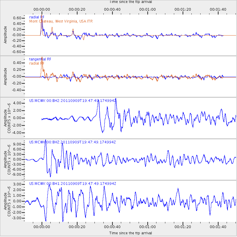
Earthquake location: Vancouver Island, Canada Region
Earthquake latitude/longitude: 49.5/-126.9
Earthquake time(UTC): 2011/09/09 (252) 19:41:34 GMT
Earthquake Depth: 22 km
Earthquake Magnitude: 6.3 MB, 6.4 MS, 6.4 MW, 6.5 MW
Earthquake Catalog/Contributor: WHDF/NEIC
Network: US United States National Seismic Network
Station: MCWV Mont Chateau, West Virginia, USA
Lat/Lon: 39.66 N/79.85 W
Elevation: 280 m
Distance: 34.4 deg
Az: 88.471 deg
Baz: 302.472 deg
Ray Param: 0.07772324
Estimated Moho Depth: 13.25 km
Estimated Crust Vp/Vs: 2.10
Assumed Crust Vp: 6.159 km/s
Estimated Crust Vs: 2.936 km/s
Estimated Crust Poisson's Ratio: 0.35
Radial Match: 91.68683 %
Radial Bump: 372
Transverse Match: 77.63643 %
Transverse Bump: 400
SOD ConfigId: 558545
Insert Time: 2013-09-19 02:39:40.279 +0000
GWidth: 2.5
Max Bumps: 400
Tol: 0.001

Signal To Noise

ChannelStoNSTALTA
US:MCWV:00:BHZ:20110909T19:47:49.174994Z16.5591756.039381E-63.6471508E-7
US:MCWV:00:BH1:20110909T19:47:49.174994Z7.15023141.9441977E-62.7190697E-7
US:MCWV:00:BH2:20110909T19:47:49.174994Z8.5736082.5788295E-63.0078695E-7
Arrivals
Ps2.5 SECOND
PpPs6.3 SECOND
PsPs/PpSs8.8 SECOND