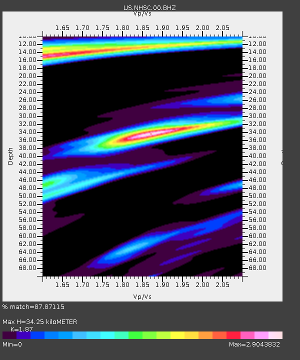
NHSC New Hope, South Carolina, USA - Earthquake Result Viewer

Earthquake location: Vancouver Island, Canada Region
Earthquake latitude/longitude: 49.5/-126.9
Earthquake time(UTC): 2011/09/09 (252) 19:41:34 GMT
Earthquake Depth: 22 km
Earthquake Magnitude: 6.3 MB, 6.4 MS, 6.4 MW, 6.5 MW
Earthquake Catalog/Contributor: WHDF/NEIC
Network: US United States National Seismic Network
Station: NHSC New Hope, South Carolina, USA
Lat/Lon: 33.11 N/80.18 W
Elevation: 11 m
Distance: 38.1 deg
Az: 97.681 deg
Baz: 309.713 deg
Ray Param: 0.0757472
Estimated Moho Depth: 34.25 km
Estimated Crust Vp/Vs: 1.87
Assumed Crust Vp: 6.565 km/s
Estimated Crust Vs: 3.51 km/s
Estimated Crust Poisson's Ratio: 0.30
Radial Match: 87.87115 %
Radial Bump: 317
Transverse Match: 67.74165 %
Transverse Bump: 396
SOD ConfigId: 558545
Insert Time: 2013-09-19 02:39:44.734 +0000
GWidth: 2.5
Max Bumps: 400
Tol: 0.001

Signal To Noise

ChannelStoNSTALTA
US:NHSC:00:BHZ:20110909T19:48:20.275Z19.9002345.352688E-62.6897615E-7
US:NHSC:00:BH1:20110909T19:48:20.275Z4.13397742.994941E-67.244696E-7
US:NHSC:00:BH2:20110909T19:48:20.275Z3.40107422.814112E-68.2741855E-7
Arrivals
Ps4.9 SECOND
PpPs14 SECOND
PsPs/PpSs19 SECOND