You are here: Home > Network List > CI - Caltech Regional Seismic Network Stations List
> Station LRL Laurel Mtn Radio Fac, Ridgecrest, CA, USA > Earthquake Result Viewer
LRL Laurel Mtn Radio Fac, Ridgecrest, CA, USA - Earthquake Result Viewer
| Earthquake location: |
Caribbean Sea |
| Earthquake latitude/longitude: |
17.8/-81.6 |
| Earthquake time(UTC): |
2004/09/09 (253) 16:33:21 GMT |
| Earthquake Depth: |
25 km |
| Earthquake Magnitude: |
5.8 MB, 5.4 MS, 6.0 MW, 6.0 MW |
| Earthquake Catalog/Contributor: |
WHDF/NEIC |
|
| Network: |
CI Caltech Regional Seismic Network |
| Station: |
LRL Laurel Mtn Radio Fac, Ridgecrest, CA, USA |
| Lat/Lon: |
35.48 N/117.68 W |
| Elevation: |
1340 m |
|
| Distance: |
36.6 deg |
| Az: |
306.09 deg |
| Baz: |
109.348 deg |
| Ray Param: |
0.07658016 |
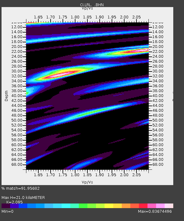
| Estimated Moho Depth: |
21.0 km |
| Estimated Crust Vp/Vs: |
2.10 |
| Assumed Crust Vp: |
6.276 km/s |
| Estimated Crust Vs: |
2.996 km/s |
| Estimated Crust Poisson's Ratio: |
0.35 |
|
| Radial Match: |
91.95682 % |
| Radial Bump: |
351 |
| Transverse Match: |
67.49782 % |
| Transverse Bump: |
400 |
| SOD ConfigId: |
2459 |
| Insert Time: |
2010-02-25 20:39:21.447 +0000 |
| GWidth: |
2.5 |
| Max Bumps: |
400 |
| Tol: |
0.001 |
|
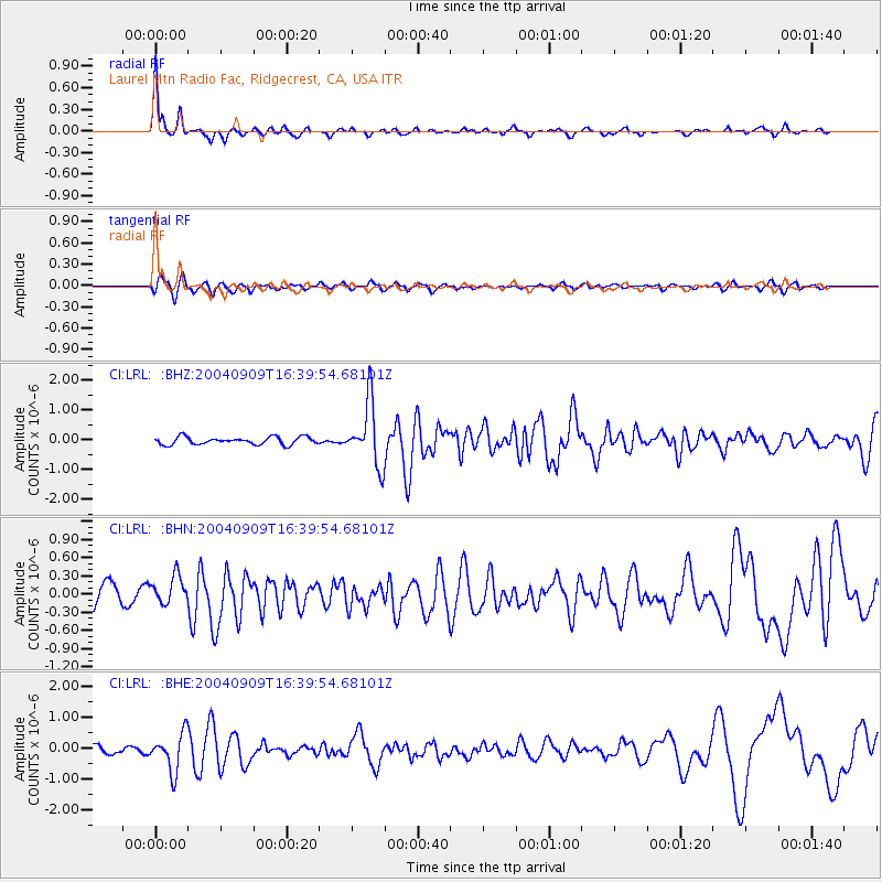
Signal To Noise
| Channel | StoN | STA | LTA |
| CI:LRL: :BHN:20040909T16:39:54.68101Z | 1.6576146 | 2.3398478E-7 | 1.4115753E-7 |
| CI:LRL: :BHE:20040909T16:39:54.68101Z | 3.0124245 | 6.092861E-7 | 2.0225772E-7 |
| CI:LRL: :BHZ:20040909T16:39:54.68101Z | 8.321803 | 1.0431855E-6 | 1.2535571E-7 |
| Arrivals |
| Ps | 3.9 SECOND |
| PpPs | 9.8 SECOND |
| PsPs/PpSs | 14 SECOND |


