You are here: Home > Network List > II - Global Seismograph Network (GSN - IRIS/IDA) Stations List
> Station WRAB Tennant Creek, NT, Australia > Earthquake Result Viewer
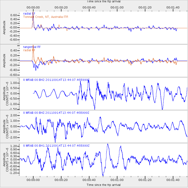
WRAB Tennant Creek, NT, Australia - Earthquake Result Viewer
*The percent match for this event was below the threshold and hence no stack was calculated.
| Earthquake location: |
East Of North Island, N.Z. |
| Earthquake latitude/longitude: |
-35.1/-179.0 |
| Earthquake time(UTC): |
2011/09/14 (257) 13:36:34 GMT |
| Earthquake Depth: |
13 km |
| Earthquake Magnitude: |
5.6 MB, 5.6 MS, 5.7 MW |
| Earthquake Catalog/Contributor: |
WHDF/NEIC |
|
| Network: |
II Global Seismograph Network (GSN - IRIS/IDA) |
| Station: |
WRAB Tennant Creek, NT, Australia |
| Lat/Lon: |
19.93 S/134.36 E |
| Elevation: |
366 m |
|
| Distance: |
43.7 deg |
| Az: |
277.654 deg |
| Baz: |
120.27 deg |
| Ray Param: |
$rayparam |
*The percent match for this event was below the threshold and hence was not used in the summary stack. |
|
| Radial Match: |
69.42457 % |
| Radial Bump: |
387 |
| Transverse Match: |
69.43022 % |
| Transverse Bump: |
400 |
| SOD ConfigId: |
558545 |
| Insert Time: |
2013-09-19 02:47:55.409 +0000 |
| GWidth: |
2.5 |
| Max Bumps: |
400 |
| Tol: |
0.001 |
|
Signal To Noise
| Channel | StoN | STA | LTA |
| II:WRAB:00:BHZ:20110914T13:44:07.468999Z | 1.7896041 | 7.19345E-7 | 4.019576E-7 |
| II:WRAB:00:BH1:20110914T13:44:07.468999Z | 2.049376 | 4.0916757E-7 | 1.996547E-7 |
| II:WRAB:00:BH2:20110914T13:44:07.468999Z | 2.1185262 | 5.3070625E-7 | 2.505073E-7 |
| Arrivals |
| Ps | |
| PpPs | |
| PsPs/PpSs | |


