You are here: Home > Network List > US - United States National Seismic Network Stations List
> Station HLID Hailey, Idaho, USA > Earthquake Result Viewer
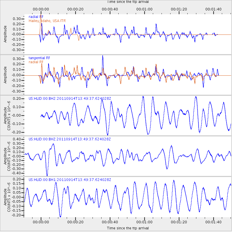
HLID Hailey, Idaho, USA - Earthquake Result Viewer
*The percent match for this event was below the threshold and hence no stack was calculated.
| Earthquake location: |
East Of North Island, N.Z. |
| Earthquake latitude/longitude: |
-35.1/-179.0 |
| Earthquake time(UTC): |
2011/09/14 (257) 13:36:34 GMT |
| Earthquake Depth: |
13 km |
| Earthquake Magnitude: |
5.6 MB, 5.6 MS, 5.7 MW |
| Earthquake Catalog/Contributor: |
WHDF/NEIC |
|
| Network: |
US United States National Seismic Network |
| Station: |
HLID Hailey, Idaho, USA |
| Lat/Lon: |
43.56 N/114.41 W |
| Elevation: |
1772 m |
|
| Distance: |
97.9 deg |
| Az: |
41.515 deg |
| Baz: |
228.378 deg |
| Ray Param: |
$rayparam |
*The percent match for this event was below the threshold and hence was not used in the summary stack. |
|
| Radial Match: |
53.30744 % |
| Radial Bump: |
334 |
| Transverse Match: |
55.765957 % |
| Transverse Bump: |
286 |
| SOD ConfigId: |
558545 |
| Insert Time: |
2013-09-19 02:48:38.010 +0000 |
| GWidth: |
2.5 |
| Max Bumps: |
400 |
| Tol: |
0.001 |
|
Signal To Noise
| Channel | StoN | STA | LTA |
| US:HLID:00:BHZ:20110914T13:49:37.624028Z | 2.808943 | 1.9047523E-7 | 6.7810284E-8 |
| US:HLID:00:BH1:20110914T13:49:37.624028Z | 0.65255135 | 4.6933895E-8 | 7.192368E-8 |
| US:HLID:00:BH2:20110914T13:49:37.624028Z | 0.84243155 | 5.078194E-8 | 6.028019E-8 |
| Arrivals |
| Ps | |
| PpPs | |
| PsPs/PpSs | |


