You are here: Home > Network List > CN - Canadian National Seismograph Network Stations List
> Station INK INUVIK, NT, CANADA.ANADA > Earthquake Result Viewer
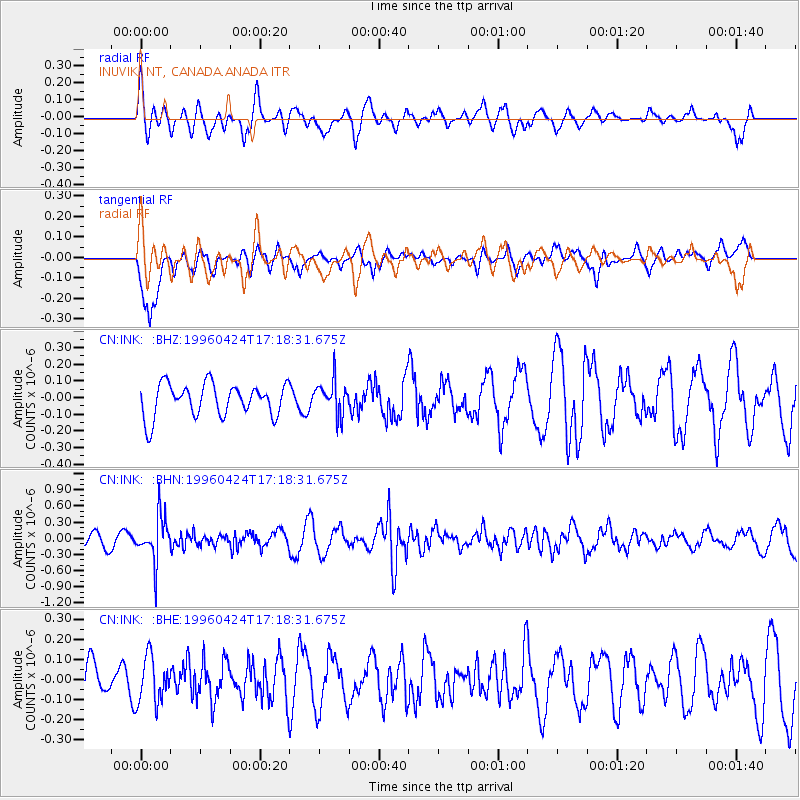
INK INUVIK, NT, CANADA.ANADA - Earthquake Result Viewer
*The percent match for this event was below the threshold and hence no stack was calculated.
| Earthquake location: |
Peru-Brazil Border Region |
| Earthquake latitude/longitude: |
-8.1/-74.4 |
| Earthquake time(UTC): |
1996/04/24 (115) 17:06:36 GMT |
| Earthquake Depth: |
151 km |
| Earthquake Magnitude: |
5.6 MB, 5.6 UNKNOWN, 5.6 MW |
| Earthquake Catalog/Contributor: |
WHDF/NEIC |
|
| Network: |
CN Canadian National Seismograph Network |
| Station: |
INK INUVIK, NT, CANADA.ANADA |
| Lat/Lon: |
68.31 N/133.52 W |
| Elevation: |
40 m |
|
| Distance: |
86.7 deg |
| Az: |
341.352 deg |
| Baz: |
121.622 deg |
| Ray Param: |
$rayparam |
*The percent match for this event was below the threshold and hence was not used in the summary stack. |
|
| Radial Match: |
52.908573 % |
| Radial Bump: |
373 |
| Transverse Match: |
59.97606 % |
| Transverse Bump: |
353 |
| SOD ConfigId: |
4480 |
| Insert Time: |
2010-02-27 06:24:21.639 +0000 |
| GWidth: |
2.5 |
| Max Bumps: |
400 |
| Tol: |
0.001 |
|
Signal To Noise
| Channel | StoN | STA | LTA |
| CN:INK: :BHN:19960424T17:18:31.675Z | 3.0631304 | 4.1287888E-7 | 1.3478984E-7 |
| CN:INK: :BHE:19960424T17:18:31.675Z | 0.84607685 | 1.1415129E-7 | 1.3491835E-7 |
| CN:INK: :BHZ:19960424T17:18:31.675Z | 1.0400397 | 1.00894084E-7 | 9.7009845E-8 |
| Arrivals |
| Ps | |
| PpPs | |
| PsPs/PpSs | |


