You are here: Home > Network List > IU - Global Seismograph Network (GSN - IRIS/USGS) Stations List
> Station TEIG Tepich, Yucatan, Mexico > Earthquake Result Viewer
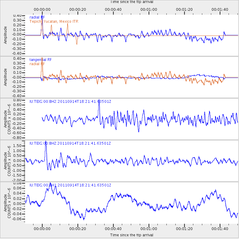
TEIG Tepich, Yucatan, Mexico - Earthquake Result Viewer
*The percent match for this event was below the threshold and hence no stack was calculated.
| Earthquake location: |
Near Islands, Aleutian Islands |
| Earthquake latitude/longitude: |
53.1/173.0 |
| Earthquake time(UTC): |
2011/09/14 (257) 18:10:09 GMT |
| Earthquake Depth: |
15 km |
| Earthquake Magnitude: |
6.1 MB, 5.7 MS, 6.0 MW, 6.0 MW |
| Earthquake Catalog/Contributor: |
WHDF/NEIC |
|
| Network: |
IU Global Seismograph Network (GSN - IRIS/USGS) |
| Station: |
TEIG Tepich, Yucatan, Mexico |
| Lat/Lon: |
20.23 N/88.28 W |
| Elevation: |
40 m |
|
| Distance: |
79.2 deg |
| Az: |
70.92 deg |
| Baz: |
322.646 deg |
| Ray Param: |
$rayparam |
*The percent match for this event was below the threshold and hence was not used in the summary stack. |
|
| Radial Match: |
61.636463 % |
| Radial Bump: |
400 |
| Transverse Match: |
34.17951 % |
| Transverse Bump: |
400 |
| SOD ConfigId: |
558545 |
| Insert Time: |
2013-09-19 02:50:29.212 +0000 |
| GWidth: |
2.5 |
| Max Bumps: |
400 |
| Tol: |
0.001 |
|
Signal To Noise
| Channel | StoN | STA | LTA |
| IU:TEIG:00:BHZ:20110914T18:21:41.63501Z | 6.7425723 | 7.482145E-7 | 1.109687E-7 |
| IU:TEIG:00:BH1:20110914T18:21:41.63501Z | 2.2111928 | 7.545196E-8 | 3.412274E-8 |
| IU:TEIG:00:BH2:20110914T18:21:41.63501Z | 2.7216516 | 2.9049946E-7 | 1.06736465E-7 |
| Arrivals |
| Ps | |
| PpPs | |
| PsPs/PpSs | |


