You are here: Home > Network List > US - United States National Seismic Network Stations List
> Station ACSO Alum Creek State Park, Ohio, USA > Earthquake Result Viewer
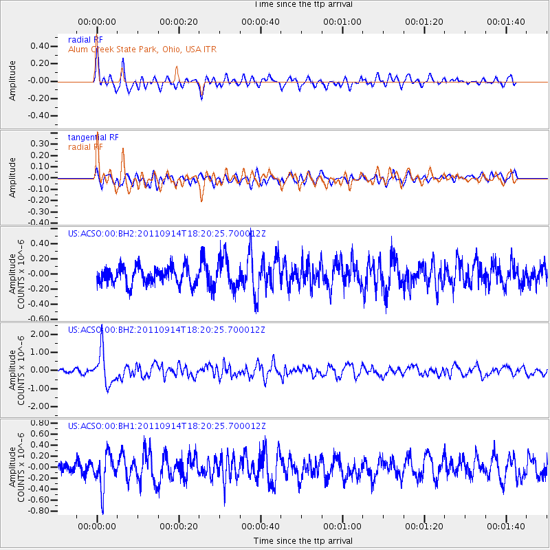
ACSO Alum Creek State Park, Ohio, USA - Earthquake Result Viewer
*The percent match for this event was below the threshold and hence no stack was calculated.
| Earthquake location: |
Near Islands, Aleutian Islands |
| Earthquake latitude/longitude: |
53.1/173.0 |
| Earthquake time(UTC): |
2011/09/14 (257) 18:10:09 GMT |
| Earthquake Depth: |
15 km |
| Earthquake Magnitude: |
6.1 MB, 5.7 MS, 6.0 MW, 6.0 MW |
| Earthquake Catalog/Contributor: |
WHDF/NEIC |
|
| Network: |
US United States National Seismic Network |
| Station: |
ACSO Alum Creek State Park, Ohio, USA |
| Lat/Lon: |
40.23 N/82.98 W |
| Elevation: |
288 m |
|
| Distance: |
66.3 deg |
| Az: |
54.184 deg |
| Baz: |
320.313 deg |
| Ray Param: |
$rayparam |
*The percent match for this event was below the threshold and hence was not used in the summary stack. |
|
| Radial Match: |
72.426384 % |
| Radial Bump: |
400 |
| Transverse Match: |
56.897026 % |
| Transverse Bump: |
400 |
| SOD ConfigId: |
558545 |
| Insert Time: |
2013-09-19 02:50:46.027 +0000 |
| GWidth: |
2.5 |
| Max Bumps: |
400 |
| Tol: |
0.001 |
|
Signal To Noise
| Channel | StoN | STA | LTA |
| US:ACSO:00:BHZ:20110914T18:20:25.700012Z | 6.08242 | 9.447069E-7 | 1.5531762E-7 |
| US:ACSO:00:BH1:20110914T18:20:25.700012Z | 2.5255919 | 3.031034E-7 | 1.2001283E-7 |
| US:ACSO:00:BH2:20110914T18:20:25.700012Z | 1.8378376 | 2.0456278E-7 | 1.11306235E-7 |
| Arrivals |
| Ps | |
| PpPs | |
| PsPs/PpSs | |


