You are here: Home > Network List > US - United States National Seismic Network Stations List
> Station HDIL Hopedale, Illinois, USA > Earthquake Result Viewer
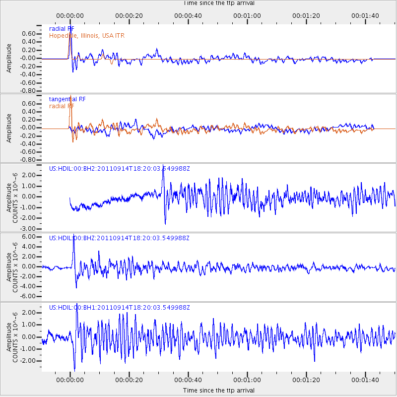
HDIL Hopedale, Illinois, USA - Earthquake Result Viewer
*The percent match for this event was below the threshold and hence no stack was calculated.
| Earthquake location: |
Near Islands, Aleutian Islands |
| Earthquake latitude/longitude: |
53.1/173.0 |
| Earthquake time(UTC): |
2011/09/14 (257) 18:10:09 GMT |
| Earthquake Depth: |
15 km |
| Earthquake Magnitude: |
6.1 MB, 5.7 MS, 6.0 MW, 6.0 MW |
| Earthquake Catalog/Contributor: |
WHDF/NEIC |
|
| Network: |
US United States National Seismic Network |
| Station: |
HDIL Hopedale, Illinois, USA |
| Lat/Lon: |
40.56 N/89.29 W |
| Elevation: |
219 m |
|
| Distance: |
62.9 deg |
| Az: |
57.98 deg |
| Baz: |
317.863 deg |
| Ray Param: |
$rayparam |
*The percent match for this event was below the threshold and hence was not used in the summary stack. |
|
| Radial Match: |
76.00572 % |
| Radial Bump: |
400 |
| Transverse Match: |
45.359943 % |
| Transverse Bump: |
400 |
| SOD ConfigId: |
558545 |
| Insert Time: |
2013-09-19 02:51:44.438 +0000 |
| GWidth: |
2.5 |
| Max Bumps: |
400 |
| Tol: |
0.001 |
|
Signal To Noise
| Channel | StoN | STA | LTA |
| US:HDIL:00:BHZ:20110914T18:20:03.549988Z | 13.320828 | 2.1243798E-6 | 1.5947805E-7 |
| US:HDIL:00:BH1:20110914T18:20:03.549988Z | 5.149604 | 1.2440419E-6 | 2.415801E-7 |
| US:HDIL:00:BH2:20110914T18:20:03.549988Z | 3.0492527 | 1.2932074E-6 | 4.2410636E-7 |
| Arrivals |
| Ps | |
| PpPs | |
| PsPs/PpSs | |


